You are here: Home > Network List > UW - Pacific Northwest Regional Seismic Network Stations List
> Station FORK Quillayute Airport, Forks, WA > Earthquake Result Viewer
FORK Quillayute Airport, Forks, WA - Earthquake Result Viewer
| Earthquake location: |
Solomon Islands |
| Earthquake latitude/longitude: |
-10.7/161.3 |
| Earthquake time(UTC): |
2016/12/08 (343) 17:38:46 GMT |
| Earthquake Depth: |
41 km |
| Earthquake Magnitude: |
7.8 mww |
| Earthquake Catalog/Contributor: |
NEIC PDE/us |
|
| Network: |
UW Pacific Northwest Regional Seismic Network |
| Station: |
FORK Quillayute Airport, Forks, WA |
| Lat/Lon: |
47.95 N/124.57 W |
| Elevation: |
48 m |
|
| Distance: |
87.4 deg |
| Az: |
40.333 deg |
| Baz: |
251.134 deg |
| Ray Param: |
0.043268196 |
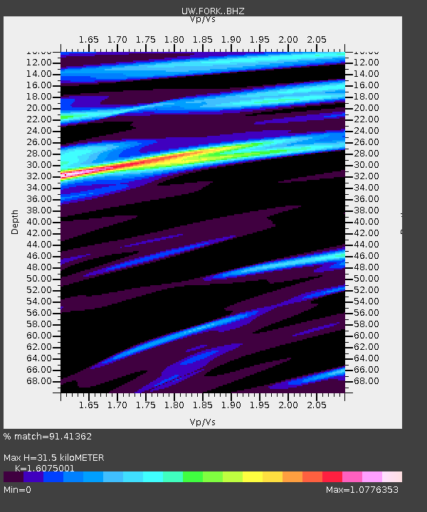
| Estimated Moho Depth: |
31.5 km |
| Estimated Crust Vp/Vs: |
1.61 |
| Assumed Crust Vp: |
6.134 km/s |
| Estimated Crust Vs: |
3.816 km/s |
| Estimated Crust Poisson's Ratio: |
0.18 |
|
| Radial Match: |
91.41362 % |
| Radial Bump: |
342 |
| Transverse Match: |
93.13049 % |
| Transverse Bump: |
400 |
| SOD ConfigId: |
11737051 |
| Insert Time: |
2019-04-26 06:06:54.655 +0000 |
| GWidth: |
2.5 |
| Max Bumps: |
400 |
| Tol: |
0.001 |
|

Signal To Noise
| Channel | StoN | STA | LTA |
| UW:FORK: :BHZ:20161208T17:50:58.249995Z | 6.860622 | 9.174267E-6 | 1.3372354E-6 |
| UW:FORK: :BHN:20161208T17:50:58.249995Z | 0.45706016 | 8.7702614E-7 | 1.9188417E-6 |
| UW:FORK: :BHE:20161208T17:50:58.249995Z | 2.4524474 | 3.3339927E-6 | 1.3594554E-6 |
| Arrivals |
| Ps | 3.2 SECOND |
| PpPs | 13 SECOND |
| PsPs/PpSs | 16 SECOND |


