You are here: Home > Network List > X416 - Monitoring Active Faults for Tectonic Mapping Efforts in Washington State Stations List
> Station MA11 Snohomish County, WA, USA > Earthquake Result Viewer
MA11 Snohomish County, WA, USA - Earthquake Result Viewer
| Earthquake location: |
Solomon Islands |
| Earthquake latitude/longitude: |
-10.7/161.3 |
| Earthquake time(UTC): |
2016/12/08 (343) 17:38:46 GMT |
| Earthquake Depth: |
41 km |
| Earthquake Magnitude: |
7.8 mww |
| Earthquake Catalog/Contributor: |
NEIC PDE/us |
|
| Network: |
X4 Monitoring Active Faults for Tectonic Mapping Efforts in Washington State |
| Station: |
MA11 Snohomish County, WA, USA |
| Lat/Lon: |
47.89 N/121.68 W |
| Elevation: |
-1.0 m |
|
| Distance: |
89.3 deg |
| Az: |
40.98 deg |
| Baz: |
253.289 deg |
| Ray Param: |
0.041914936 |
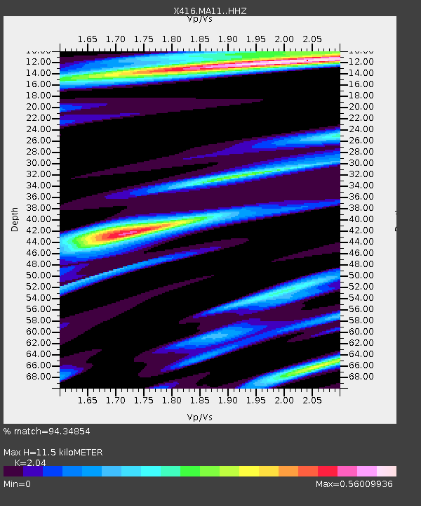
| Estimated Moho Depth: |
11.5 km |
| Estimated Crust Vp/Vs: |
2.04 |
| Assumed Crust Vp: |
6.597 km/s |
| Estimated Crust Vs: |
3.234 km/s |
| Estimated Crust Poisson's Ratio: |
0.34 |
|
| Radial Match: |
94.34854 % |
| Radial Bump: |
400 |
| Transverse Match: |
90.432526 % |
| Transverse Bump: |
400 |
| SOD ConfigId: |
11737051 |
| Insert Time: |
2019-04-26 06:07:22.365 +0000 |
| GWidth: |
2.5 |
| Max Bumps: |
400 |
| Tol: |
0.001 |
|

Signal To Noise
| Channel | StoN | STA | LTA |
| X4:MA11: :HHZ:20161208T17:51:06.919978Z | 31.689281 | 8.124683E-6 | 2.5638582E-7 |
| X4:MA11: :HHN:20161208T17:51:06.919978Z | 5.377421 | 1.6143389E-6 | 3.0020692E-7 |
| X4:MA11: :HHE:20161208T17:51:06.919978Z | 9.994446 | 1.6530619E-6 | 1.6539805E-7 |
| Arrivals |
| Ps | 1.8 SECOND |
| PpPs | 5.2 SECOND |
| PsPs/PpSs | 7.0 SECOND |


