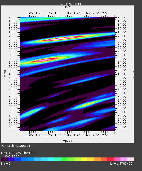
MPM Manuel Prospect Mine, California, USA - Earthquake Result Viewer
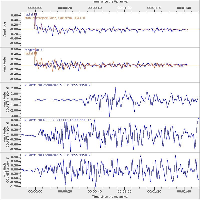
Earthquake location: Fox Islands, Aleutian Islands
Earthquake latitude/longitude: 52.5/-168.0
Earthquake time(UTC): 2007/07/15 (196) 13:08:00 GMT
Earthquake Depth: 10 km
Earthquake Magnitude: 5.8 MB, 5.9 MS, 6.1 MW, 6.0 MW
Earthquake Catalog/Contributor: WHDF/NEIC
Network: CI Caltech Regional Seismic Network
Station: MPM Manuel Prospect Mine, California, USA
Lat/Lon: 36.06 N/117.49 W
Elevation: 185 m
Distance: 38.9 deg
Az: 94.463 deg
Baz: 311.19 deg
Ray Param: 0.075307496
Estimated Moho Depth: 21.25 km
Estimated Crust Vp/Vs: 1.80
Assumed Crust Vp: 6.279 km/s
Estimated Crust Vs: 3.483 km/s
Estimated Crust Poisson's Ratio: 0.28
Radial Match: 91.55121 %
Radial Bump: 400
Transverse Match: 84.37341 %
Transverse Bump: 400
SOD ConfigId: 2564
Insert Time: 2010-03-05 20:20:15.904 +0000
GWidth: 2.5
Max Bumps: 400
Tol: 0.001

Signal To Noise

ChannelStoNSTALTA
CI:MPM: :BHN:20070715T13:14:55.44501Z3.04129311.4881253E-74.8930676E-8
CI:MPM: :BHE:20070715T13:14:55.44501Z4.6234191.9937369E-74.3122565E-8
CI:MPM: :BHZ:20070715T13:14:55.44501Z6.55526974.2777296E-76.5256344E-8
Arrivals
Ps2.9 SECOND
PpPs8.9 SECOND
PsPs/PpSs12 SECOND