You are here: Home > Network List > YN10 - San Jacinto Fault Zone Stations List
> Station TR03 TR03 > Earthquake Result Viewer
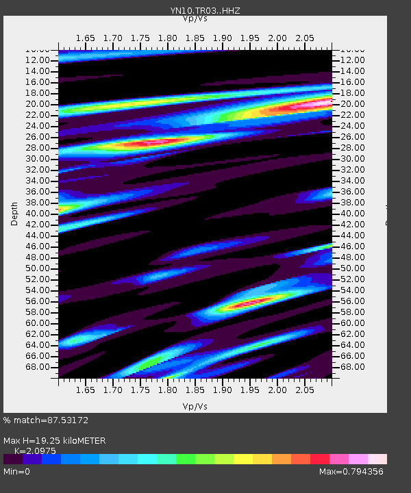
TR03 TR03 - Earthquake Result Viewer
| Earthquake location: |
Solomon Islands |
| Earthquake latitude/longitude: |
-10.7/161.3 |
| Earthquake time(UTC): |
2016/12/08 (343) 17:38:46 GMT |
| Earthquake Depth: |
41 km |
| Earthquake Magnitude: |
7.8 mww |
| Earthquake Catalog/Contributor: |
NEIC PDE/us |
|
| Network: |
YN San Jacinto Fault Zone |
| Station: |
TR03 TR03 |
| Lat/Lon: |
33.41 N/116.42 W |
| Elevation: |
739 m |
|
| Distance: |
89.4 deg |
| Az: |
55.98 deg |
| Baz: |
256.901 deg |
| Ray Param: |
0.041801132 |
| Estimated Moho Depth: |
19.25 km |
| Estimated Crust Vp/Vs: |
2.10 |
| Assumed Crust Vp: |
6.264 km/s |
| Estimated Crust Vs: |
2.986 km/s |
| Estimated Crust Poisson's Ratio: |
0.35 |
|
| Radial Match: |
87.53172 % |
| Radial Bump: |
400 |
| Transverse Match: |
86.67427 % |
| Transverse Bump: |
360 |
| SOD ConfigId: |
11737051 |
| Insert Time: |
2019-04-26 06:07:52.805 +0000 |
| GWidth: |
2.5 |
| Max Bumps: |
400 |
| Tol: |
0.001 |
|

Signal To Noise
| Channel | StoN | STA | LTA |
| YN:TR03: :HHZ:20161208T17:51:07.643977Z | 17.377937 | 7.825714E-6 | 4.5032468E-7 |
| YN:TR03: :HHN:20161208T17:51:07.643977Z | 6.92399 | 1.6066982E-6 | 2.3204805E-7 |
| YN:TR03: :HHE:20161208T17:51:07.643977Z | 6.628612 | 2.0953248E-6 | 3.1610313E-7 |
| Arrivals |
| Ps | 3.4 SECOND |
| PpPs | 9.4 SECOND |
| PsPs/PpSs | 13 SECOND |


