You are here: Home > Network List > CI - Caltech Regional Seismic Network Stations List
> Station MPM Manuel Prospect Mine, California, USA > Earthquake Result Viewer
MPM Manuel Prospect Mine, California, USA - Earthquake Result Viewer
| Earthquake location: |
Near Coast Of Guatemala |
| Earthquake latitude/longitude: |
13.6/-90.6 |
| Earthquake time(UTC): |
2007/06/13 (164) 19:29:40 GMT |
| Earthquake Depth: |
23 km |
| Earthquake Magnitude: |
5.9 MB, 6.5 MS, 6.7 MW, 6.5 MW |
| Earthquake Catalog/Contributor: |
WHDF/NEIC |
|
| Network: |
CI Caltech Regional Seismic Network |
| Station: |
MPM Manuel Prospect Mine, California, USA |
| Lat/Lon: |
36.06 N/117.49 W |
| Elevation: |
185 m |
|
| Distance: |
32.9 deg |
| Az: |
317.635 deg |
| Baz: |
126.027 deg |
| Ray Param: |
0.07841674 |
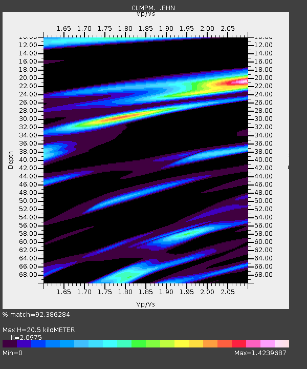
| Estimated Moho Depth: |
20.5 km |
| Estimated Crust Vp/Vs: |
2.10 |
| Assumed Crust Vp: |
6.279 km/s |
| Estimated Crust Vs: |
2.993 km/s |
| Estimated Crust Poisson's Ratio: |
0.35 |
|
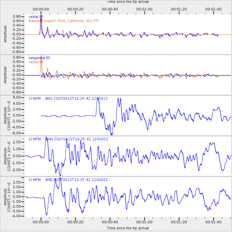
| Radial Match: |
92.386284 % |
| Radial Bump: |
391 |
| Transverse Match: |
69.00949 % |
| Transverse Bump: |
400 |
| SOD ConfigId: |
2564 |
| Insert Time: |
2010-03-05 20:20:23.018 +0000 |
| GWidth: |
2.5 |
| Max Bumps: |
400 |
| Tol: |
0.001 |
|
Signal To Noise
| Channel | StoN | STA | LTA |
| CI:MPM: :BHN:20070613T19:35:42.120002Z | 15.389869 | 1.3436174E-6 | 8.730532E-8 |
| CI:MPM: :BHE:20070613T19:35:42.120002Z | 10.137379 | 1.703572E-6 | 1.6804856E-7 |
| CI:MPM: :BHZ:20070613T19:35:42.120002Z | 18.645107 | 2.9141297E-6 | 1.562946E-7 |
| Arrivals |
| Ps | 3.8 SECOND |
| PpPs | 9.5 SECOND |
| PsPs/PpSs | 13 SECOND |


