You are here: Home > Network List > CI - Caltech Regional Seismic Network Stations List
> Station MPM Manuel Prospect Mine, California, USA > Earthquake Result Viewer
MPM Manuel Prospect Mine, California, USA - Earthquake Result Viewer
| Earthquake location: |
Solomon Islands |
| Earthquake latitude/longitude: |
-8.5/157.0 |
| Earthquake time(UTC): |
2007/04/01 (091) 20:39:56 GMT |
| Earthquake Depth: |
10 km |
| Earthquake Magnitude: |
6.8 MB, 7.9 MS, 8.1 MW, 7.7 ME |
| Earthquake Catalog/Contributor: |
WHDF/NEIC |
|
| Network: |
CI Caltech Regional Seismic Network |
| Station: |
MPM Manuel Prospect Mine, California, USA |
| Lat/Lon: |
36.06 N/117.49 W |
| Elevation: |
185 m |
|
| Distance: |
91.3 deg |
| Az: |
53.897 deg |
| Baz: |
260.544 deg |
| Ray Param: |
0.04161349 |
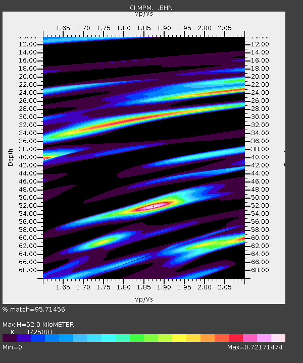
| Estimated Moho Depth: |
52.0 km |
| Estimated Crust Vp/Vs: |
1.87 |
| Assumed Crust Vp: |
6.279 km/s |
| Estimated Crust Vs: |
3.353 km/s |
| Estimated Crust Poisson's Ratio: |
0.30 |
|
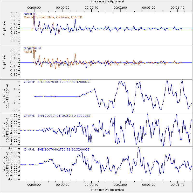
| Radial Match: |
95.71456 % |
| Radial Bump: |
400 |
| Transverse Match: |
89.076195 % |
| Transverse Bump: |
400 |
| SOD ConfigId: |
2564 |
| Insert Time: |
2010-03-05 20:20:32.142 +0000 |
| GWidth: |
2.5 |
| Max Bumps: |
400 |
| Tol: |
0.001 |
|
Signal To Noise
| Channel | StoN | STA | LTA |
| CI:MPM: :BHN:20070401T20:52:30.320002Z | 0.76830125 | 7.5680916E-8 | 9.8504216E-8 |
| CI:MPM: :BHE:20070401T20:52:30.320002Z | 2.4034703 | 3.4661593E-7 | 1.4421478E-7 |
| CI:MPM: :BHZ:20070401T20:52:30.320002Z | 6.7522554 | 1.4014116E-6 | 2.0754719E-7 |
| Arrivals |
| Ps | 7.4 SECOND |
| PpPs | 23 SECOND |
| PsPs/PpSs | 31 SECOND |


