You are here: Home > Network List > AV - Alaska Volcano Observatory Stations List
> Station AU22 Augustine Mound, Augustine Volcano, Alaska > Earthquake Result Viewer
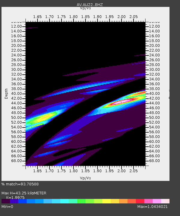
AU22 Augustine Mound, Augustine Volcano, Alaska - Earthquake Result Viewer
| Earthquake location: |
Solomon Islands |
| Earthquake latitude/longitude: |
-10.4/161.3 |
| Earthquake time(UTC): |
2016/12/08 (343) 18:03:05 GMT |
| Earthquake Depth: |
42 km |
| Earthquake Magnitude: |
5.6 mb |
| Earthquake Catalog/Contributor: |
NEIC PDE/us |
|
| Network: |
AV Alaska Volcano Observatory |
| Station: |
AU22 Augustine Mound, Augustine Volcano, Alaska |
| Lat/Lon: |
59.34 N/153.36 W |
| Elevation: |
105 m |
|
| Distance: |
78.4 deg |
| Az: |
21.84 deg |
| Baz: |
225.571 deg |
| Ray Param: |
0.04959125 |
| Estimated Moho Depth: |
43.25 km |
| Estimated Crust Vp/Vs: |
2.00 |
| Assumed Crust Vp: |
5.989 km/s |
| Estimated Crust Vs: |
2.998 km/s |
| Estimated Crust Poisson's Ratio: |
0.33 |
|
| Radial Match: |
93.78588 % |
| Radial Bump: |
400 |
| Transverse Match: |
56.044704 % |
| Transverse Bump: |
208 |
| SOD ConfigId: |
11737051 |
| Insert Time: |
2019-04-26 06:10:28.890 +0000 |
| GWidth: |
2.5 |
| Max Bumps: |
400 |
| Tol: |
0.001 |
|

Signal To Noise
| Channel | StoN | STA | LTA |
| AV:AU22: :BHZ:20161208T18:14:30.478979Z | 8.337568 | 5.9247388E-5 | 7.106075E-6 |
| AV:AU22: :BHN:20161208T18:14:30.478979Z | 1.1912328 | 3.379997E-5 | 2.8373943E-5 |
| AV:AU22: :BHE:20161208T18:14:30.478979Z | 1.5663421 | 4.8964033E-5 | 3.1260115E-5 |
| Arrivals |
| Ps | 7.4 SECOND |
| PpPs | 21 SECOND |
| PsPs/PpSs | 29 SECOND |


