You are here: Home > Network List > AV - Alaska Volcano Observatory Stations List
> Station AUL Lava Flow, Augustine Volcano, Alaska > Earthquake Result Viewer
AUL Lava Flow, Augustine Volcano, Alaska - Earthquake Result Viewer
| Earthquake location: |
Solomon Islands |
| Earthquake latitude/longitude: |
-10.4/161.3 |
| Earthquake time(UTC): |
2016/12/08 (343) 18:03:05 GMT |
| Earthquake Depth: |
42 km |
| Earthquake Magnitude: |
5.6 mb |
| Earthquake Catalog/Contributor: |
NEIC PDE/us |
|
| Network: |
AV Alaska Volcano Observatory |
| Station: |
AUL Lava Flow, Augustine Volcano, Alaska |
| Lat/Lon: |
59.38 N/153.44 W |
| Elevation: |
360 m |
|
| Distance: |
78.4 deg |
| Az: |
21.778 deg |
| Baz: |
225.49 deg |
| Ray Param: |
0.04958998 |
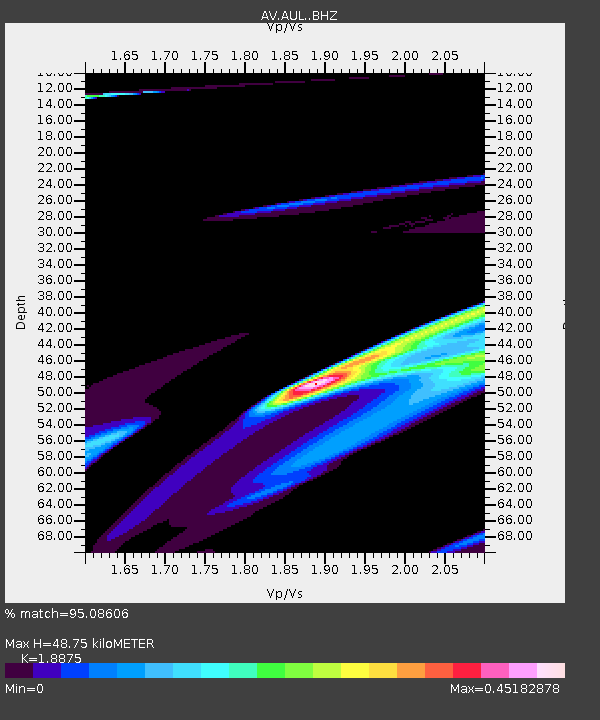
| Estimated Moho Depth: |
48.75 km |
| Estimated Crust Vp/Vs: |
1.89 |
| Assumed Crust Vp: |
5.989 km/s |
| Estimated Crust Vs: |
3.173 km/s |
| Estimated Crust Poisson's Ratio: |
0.30 |
|
| Radial Match: |
95.08606 % |
| Radial Bump: |
261 |
| Transverse Match: |
71.67615 % |
| Transverse Bump: |
400 |
| SOD ConfigId: |
11737051 |
| Insert Time: |
2019-04-26 06:10:29.392 +0000 |
| GWidth: |
2.5 |
| Max Bumps: |
400 |
| Tol: |
0.001 |
|

Signal To Noise
| Channel | StoN | STA | LTA |
| AV:AUL: :BHZ:20161208T18:14:30.360022Z | 10.088171 | 3.485318E-5 | 3.454856E-6 |
| AV:AUL: :BHN:20161208T18:14:30.360022Z | 1.2487062 | 2.301592E-5 | 1.8431814E-5 |
| AV:AUL: :BHE:20161208T18:14:30.360022Z | 1.4589736 | 2.806229E-5 | 1.9234269E-5 |
| Arrivals |
| Ps | 7.4 SECOND |
| PpPs | 23 SECOND |
| PsPs/PpSs | 30 SECOND |


