You are here: Home > Network List > AV - Alaska Volcano Observatory Stations List
> Station AUSS Augustine Summit Station, Augustine Volcano, Alaska > Earthquake Result Viewer
AUSS Augustine Summit Station, Augustine Volcano, Alaska - Earthquake Result Viewer
| Earthquake location: |
Solomon Islands |
| Earthquake latitude/longitude: |
-10.4/161.3 |
| Earthquake time(UTC): |
2016/12/08 (343) 18:03:05 GMT |
| Earthquake Depth: |
42 km |
| Earthquake Magnitude: |
5.6 mb |
| Earthquake Catalog/Contributor: |
NEIC PDE/us |
|
| Network: |
AV Alaska Volcano Observatory |
| Station: |
AUSS Augustine Summit Station, Augustine Volcano, Alaska |
| Lat/Lon: |
59.36 N/153.43 W |
| Elevation: |
1235 m |
|
| Distance: |
78.4 deg |
| Az: |
21.797 deg |
| Baz: |
225.5 deg |
| Ray Param: |
0.049599096 |
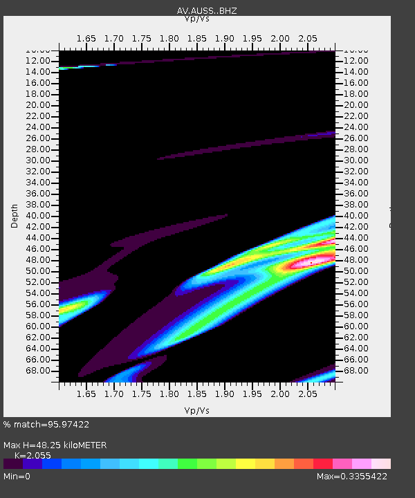
| Estimated Moho Depth: |
48.25 km |
| Estimated Crust Vp/Vs: |
2.06 |
| Assumed Crust Vp: |
5.989 km/s |
| Estimated Crust Vs: |
2.914 km/s |
| Estimated Crust Poisson's Ratio: |
0.34 |
|
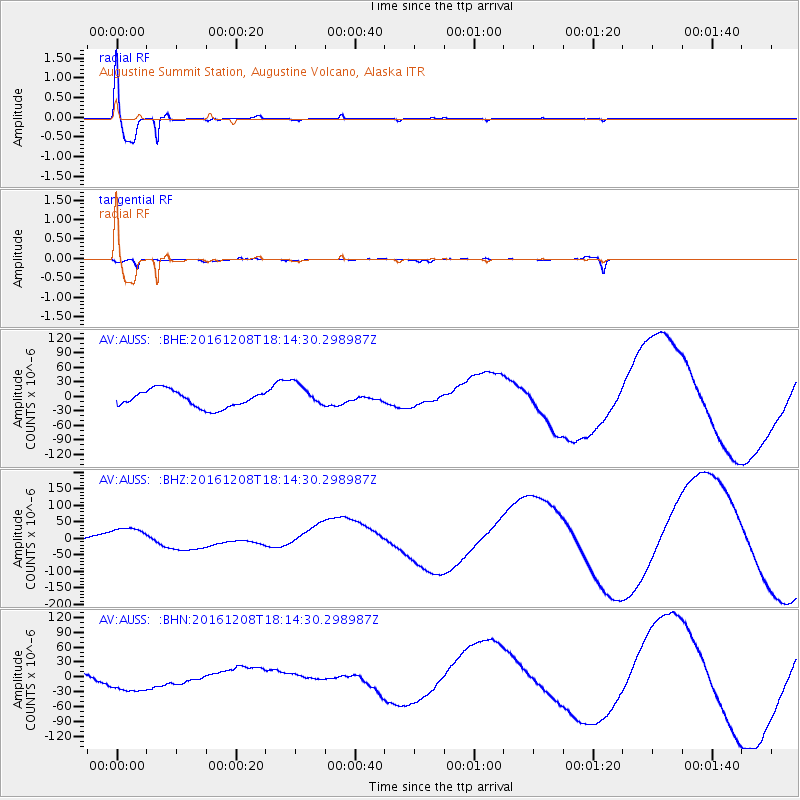
| Radial Match: |
95.97422 % |
| Radial Bump: |
267 |
| Transverse Match: |
75.812775 % |
| Transverse Bump: |
289 |
| SOD ConfigId: |
11737051 |
| Insert Time: |
2019-04-26 06:10:30.487 +0000 |
| GWidth: |
2.5 |
| Max Bumps: |
400 |
| Tol: |
0.001 |
|
Signal To Noise
| Channel | StoN | STA | LTA |
| AV:AUSS: :BHZ:20161208T18:14:30.298987Z | 10.582889 | 3.5242887E-5 | 3.3301767E-6 |
| AV:AUSS: :BHN:20161208T18:14:30.298987Z | 1.2951878 | 2.501428E-5 | 1.9313246E-5 |
| AV:AUSS: :BHE:20161208T18:14:30.298987Z | 1.469084 | 2.5412326E-5 | 1.7298074E-5 |
| Arrivals |
| Ps | 8.7 SECOND |
| PpPs | 24 SECOND |
| PsPs/PpSs | 33 SECOND |


