You are here: Home > Network List > UU - University of Utah Regional Network Stations List
> Station BSUT Blindstream Canyon, Hanna, UT, USA > Earthquake Result Viewer
BSUT Blindstream Canyon, Hanna, UT, USA - Earthquake Result Viewer
| Earthquake location: |
Vanuatu Islands |
| Earthquake latitude/longitude: |
-14.8/167.3 |
| Earthquake time(UTC): |
2015/10/20 (293) 21:52:02 GMT |
| Earthquake Depth: |
127 km |
| Earthquake Magnitude: |
7.1 MWW, 7.3 MI |
| Earthquake Catalog/Contributor: |
NEIC PDE/NEIC COMCAT |
|
| Network: |
UU University of Utah Regional Network |
| Station: |
BSUT Blindstream Canyon, Hanna, UT, USA |
| Lat/Lon: |
40.54 N/110.76 W |
| Elevation: |
3211 m |
|
| Distance: |
93.5 deg |
| Az: |
49.115 deg |
| Baz: |
253.597 deg |
| Ray Param: |
0.041172937 |
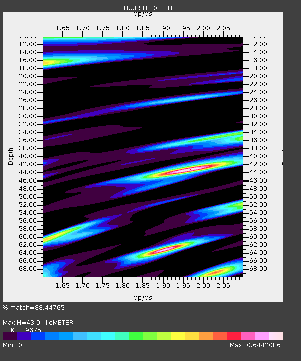
| Estimated Moho Depth: |
43.0 km |
| Estimated Crust Vp/Vs: |
1.97 |
| Assumed Crust Vp: |
6.155 km/s |
| Estimated Crust Vs: |
3.128 km/s |
| Estimated Crust Poisson's Ratio: |
0.33 |
|
| Radial Match: |
88.44765 % |
| Radial Bump: |
400 |
| Transverse Match: |
77.80412 % |
| Transverse Bump: |
400 |
| SOD ConfigId: |
1259291 |
| Insert Time: |
2015-11-03 22:23:31.763 +0000 |
| GWidth: |
2.5 |
| Max Bumps: |
400 |
| Tol: |
0.001 |
|

Signal To Noise
| Channel | StoN | STA | LTA |
| UU:BSUT:01:HHZ:20151020T22:04:32.138013Z | 23.23336 | 1.0466991E-7 | 4.505156E-9 |
| UU:BSUT:01:HHN:20151020T22:04:32.138013Z | 4.5191474 | 1.5524046E-8 | 3.4351715E-9 |
| UU:BSUT:01:HHE:20151020T22:04:32.138013Z | 10.304711 | 3.17789E-8 | 3.0839193E-9 |
| Arrivals |
| Ps | 6.9 SECOND |
| PpPs | 20 SECOND |
| PsPs/PpSs | 27 SECOND |


