You are here: Home > Network List > CI - Caltech Regional Seismic Network Stations List
> Station MPM Manuel Prospect Mine, California, USA > Earthquake Result Viewer
MPM Manuel Prospect Mine, California, USA - Earthquake Result Viewer
| Earthquake location: |
Kodiak Island Region, Alaska |
| Earthquake latitude/longitude: |
57.4/-154.4 |
| Earthquake time(UTC): |
1999/12/06 (340) 23:22:55 GMT |
| Earthquake Depth: |
50 km |
| Earthquake Magnitude: |
5.6 MB, 5.5 ML, 5.4 ML |
| Earthquake Catalog/Contributor: |
WHDF/NEIC |
|
| Network: |
CI Caltech Regional Seismic Network |
| Station: |
MPM Manuel Prospect Mine, California, USA |
| Lat/Lon: |
36.06 N/117.49 W |
| Elevation: |
185 m |
|
| Distance: |
32.5 deg |
| Az: |
115.003 deg |
| Baz: |
322.693 deg |
| Ray Param: |
0.078533426 |
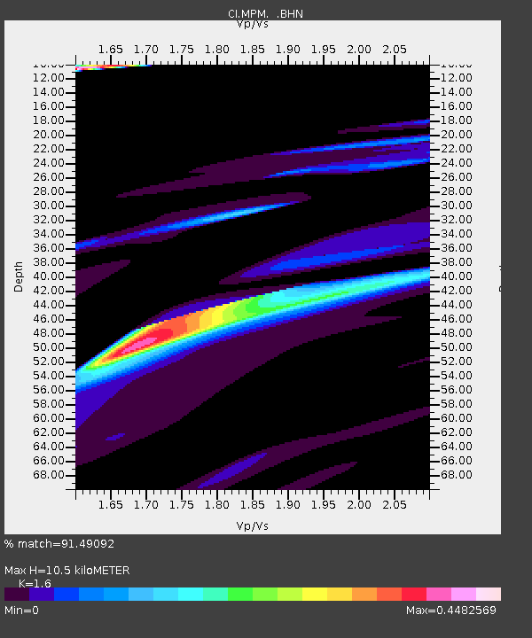
| Estimated Moho Depth: |
10.5 km |
| Estimated Crust Vp/Vs: |
1.60 |
| Assumed Crust Vp: |
6.279 km/s |
| Estimated Crust Vs: |
3.924 km/s |
| Estimated Crust Poisson's Ratio: |
0.18 |
|
| Radial Match: |
91.49092 % |
| Radial Bump: |
400 |
| Transverse Match: |
75.38333 % |
| Transverse Bump: |
400 |
| SOD ConfigId: |
3770 |
| Insert Time: |
2010-03-05 20:20:43.128 +0000 |
| GWidth: |
2.5 |
| Max Bumps: |
400 |
| Tol: |
0.001 |
|
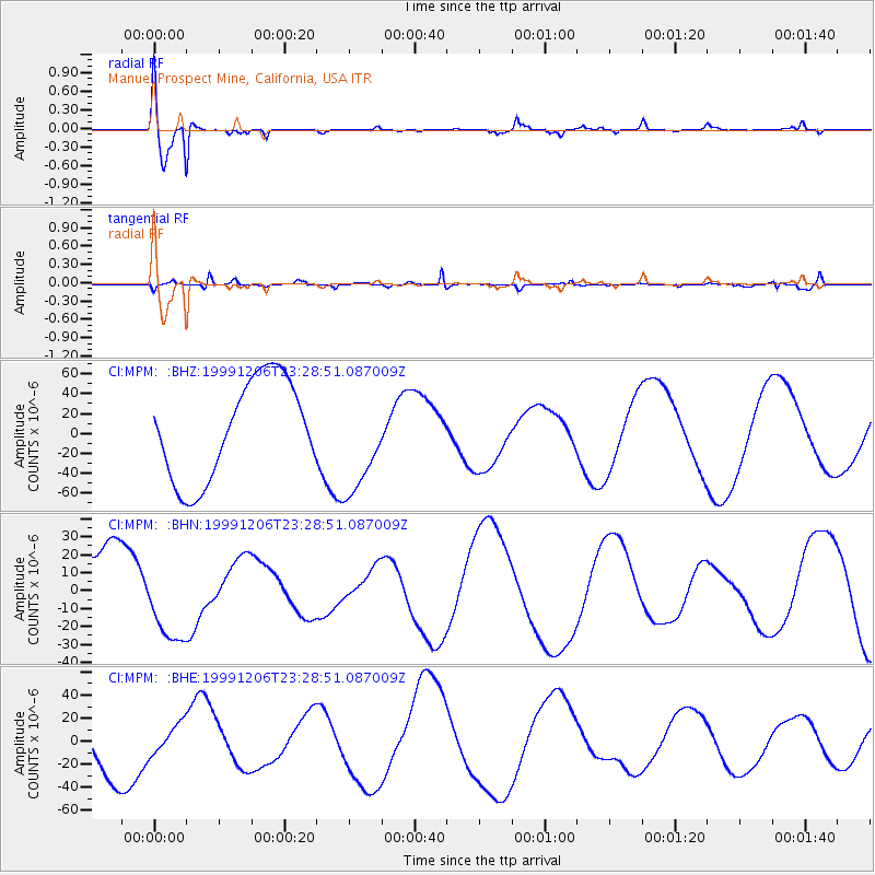
Signal To Noise
| Channel | StoN | STA | LTA |
| CI:MPM: :BHN:19991206T23:28:51.087009Z | 0.83143663 | 2.571498E-5 | 3.092837E-5 |
| CI:MPM: :BHE:19991206T23:28:51.087009Z | 0.4611436 | 1.4234619E-5 | 3.0868083E-5 |
| CI:MPM: :BHZ:19991206T23:28:51.087009Z | 1.0331677 | 5.108394E-5 | 4.9443996E-5 |
| Arrivals |
| Ps | 1.1 SECOND |
| PpPs | 4.0 SECOND |
| PsPs/PpSs | 5.1 SECOND |


