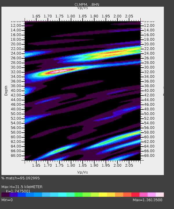
MPM Manuel Prospect Mine, California, USA - Earthquake Result Viewer
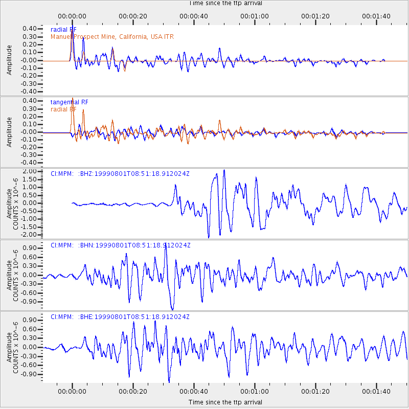
Earthquake location: Kermadec Islands, New Zealand
Earthquake latitude/longitude: -30.4/-177.8
Earthquake time(UTC): 1999/08/01 (213) 08:39:04 GMT
Earthquake Depth: 10 km
Earthquake Magnitude: 5.7 MB, 6.4 MS, 6.6 MW, 6.0 ME
Earthquake Catalog/Contributor: WHDF/NEIC
Network: CI Caltech Regional Seismic Network
Station: MPM Manuel Prospect Mine, California, USA
Lat/Lon: 36.06 N/117.49 W
Elevation: 185 m
Distance: 87.0 deg
Az: 44.837 deg
Baz: 228.77 deg
Ray Param: 0.04361666
Estimated Moho Depth: 31.5 km
Estimated Crust Vp/Vs: 1.75
Assumed Crust Vp: 6.279 km/s
Estimated Crust Vs: 3.593 km/s
Estimated Crust Poisson's Ratio: 0.26
Radial Match: 95.092995 %
Radial Bump: 400
Transverse Match: 91.92182 %
Transverse Bump: 400
SOD ConfigId: 3787
Insert Time: 2010-03-05 20:20:50.525 +0000
GWidth: 2.5
Max Bumps: 400
Tol: 0.001

Signal To Noise

ChannelStoNSTALTA
CI:MPM: :BHN:19990801T08:51:18.912024Z3.46263121.4656987E-74.2329045E-8
CI:MPM: :BHE:19990801T08:51:18.912024Z2.30049351.3143688E-75.713421E-8
CI:MPM: :BHZ:19990801T08:51:18.912024Z8.8231444.0258925E-74.5628777E-8
Arrivals
Ps3.8 SECOND
PpPs13 SECOND
PsPs/PpSs17 SECOND