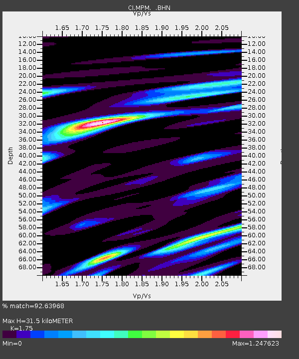
MPM Manuel Prospect Mine, California, USA - Earthquake Result Viewer
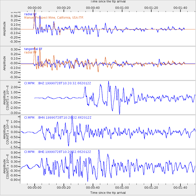
Earthquake location: Kermadec Islands, New Zealand
Earthquake latitude/longitude: -30.3/-178.0
Earthquake time(UTC): 1999/07/28 (209) 10:08:20 GMT
Earthquake Depth: 25 km
Earthquake Magnitude: 6.1 MB, 6.0 MS, 6.3 MW, 6.1 ME
Earthquake Catalog/Contributor: WHDF/NEIC
Network: CI Caltech Regional Seismic Network
Station: MPM Manuel Prospect Mine, California, USA
Lat/Lon: 36.06 N/117.49 W
Elevation: 185 m
Distance: 87.1 deg
Az: 44.937 deg
Baz: 228.939 deg
Ray Param: 0.04355061
Estimated Moho Depth: 31.5 km
Estimated Crust Vp/Vs: 1.75
Assumed Crust Vp: 6.279 km/s
Estimated Crust Vs: 3.588 km/s
Estimated Crust Poisson's Ratio: 0.26
Radial Match: 92.63968 %
Radial Bump: 400
Transverse Match: 87.69809 %
Transverse Bump: 400
SOD ConfigId: 3787
Insert Time: 2010-03-05 20:20:52.409 +0000
GWidth: 2.5
Max Bumps: 400
Tol: 0.001

Signal To Noise

ChannelStoNSTALTA
CI:MPM: :BHN:19990728T10:20:32.662012Z2.20754431.8451985E-78.358602E-8
CI:MPM: :BHE:19990728T10:20:32.662012Z1.72002331.6696957E-79.707402E-8
CI:MPM: :BHZ:19990728T10:20:32.662012Z6.7750726.852984E-71.0114998E-7
Arrivals
Ps3.8 SECOND
PpPs13 SECOND
PsPs/PpSs17 SECOND