You are here: Home > Network List > UU - University of Utah Regional Network Stations List
> Station NOQ North Oquirrh Mountains, UT, USA > Earthquake Result Viewer
NOQ North Oquirrh Mountains, UT, USA - Earthquake Result Viewer
| Earthquake location: |
Vanuatu Islands |
| Earthquake latitude/longitude: |
-14.8/167.3 |
| Earthquake time(UTC): |
2015/10/20 (293) 21:52:02 GMT |
| Earthquake Depth: |
127 km |
| Earthquake Magnitude: |
7.1 MWW, 7.3 MI |
| Earthquake Catalog/Contributor: |
NEIC PDE/NEIC COMCAT |
|
| Network: |
UU University of Utah Regional Network |
| Station: |
NOQ North Oquirrh Mountains, UT, USA |
| Lat/Lon: |
40.65 N/112.12 W |
| Elevation: |
1622 m |
|
| Distance: |
92.6 deg |
| Az: |
48.704 deg |
| Baz: |
252.738 deg |
| Ray Param: |
0.0413628 |
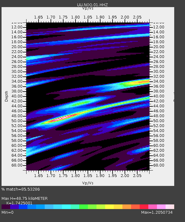
| Estimated Moho Depth: |
48.75 km |
| Estimated Crust Vp/Vs: |
1.74 |
| Assumed Crust Vp: |
6.276 km/s |
| Estimated Crust Vs: |
3.602 km/s |
| Estimated Crust Poisson's Ratio: |
0.25 |
|
| Radial Match: |
85.53286 % |
| Radial Bump: |
400 |
| Transverse Match: |
79.79822 % |
| Transverse Bump: |
400 |
| SOD ConfigId: |
1259291 |
| Insert Time: |
2015-11-03 22:24:15.021 +0000 |
| GWidth: |
2.5 |
| Max Bumps: |
400 |
| Tol: |
0.001 |
|

Signal To Noise
| Channel | StoN | STA | LTA |
| UU:NOQ:01:HHZ:20151020T22:04:27.769971Z | 21.966505 | 1.0633401E-7 | 4.8407336E-9 |
| UU:NOQ:01:HHN:20151020T22:04:27.769971Z | 3.00873 | 1.03854445E-8 | 3.4517704E-9 |
| UU:NOQ:01:HHE:20151020T22:04:27.769971Z | 6.445024 | 3.252079E-8 | 5.045876E-9 |
| Arrivals |
| Ps | 5.9 SECOND |
| PpPs | 21 SECOND |
| PsPs/PpSs | 27 SECOND |


