You are here: Home > Network List > TA - USArray Transportable Network (new EarthScope stations) Stations List
> Station O17K Koliganek, Bristol Bay, AK, USA > Earthquake Result Viewer
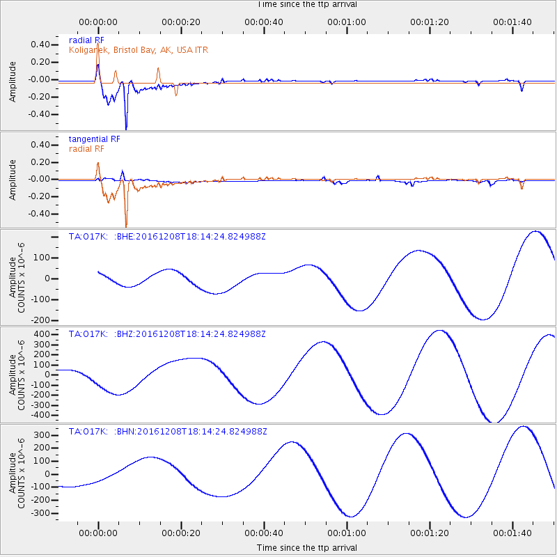
O17K Koliganek, Bristol Bay, AK, USA - Earthquake Result Viewer
*The percent match for this event was below the threshold and hence no stack was calculated.
| Earthquake location: |
Solomon Islands |
| Earthquake latitude/longitude: |
-10.4/161.3 |
| Earthquake time(UTC): |
2016/12/08 (343) 18:03:05 GMT |
| Earthquake Depth: |
42 km |
| Earthquake Magnitude: |
5.6 mb |
| Earthquake Catalog/Contributor: |
NEIC PDE/us |
|
| Network: |
TA USArray Transportable Network (new EarthScope stations) |
| Station: |
O17K Koliganek, Bristol Bay, AK, USA |
| Lat/Lon: |
59.77 N/157.09 W |
| Elevation: |
156 m |
|
| Distance: |
77.4 deg |
| Az: |
20.125 deg |
| Baz: |
221.996 deg |
| Ray Param: |
$rayparam |
*The percent match for this event was below the threshold and hence was not used in the summary stack. |
|
| Radial Match: |
96.70519 % |
| Radial Bump: |
339 |
| Transverse Match: |
77.56733 % |
| Transverse Bump: |
267 |
| SOD ConfigId: |
11737051 |
| Insert Time: |
2019-04-26 06:13:58.217 +0000 |
| GWidth: |
2.5 |
| Max Bumps: |
400 |
| Tol: |
0.001 |
|
Signal To Noise
| Channel | StoN | STA | LTA |
| TA:O17K: :BHZ:20161208T18:14:24.824988Z | 6.1181297 | 1.7318103E-4 | 2.8306204E-5 |
| TA:O17K: :BHN:20161208T18:14:24.824988Z | 0.48935303 | 2.7204173E-5 | 5.5592118E-5 |
| TA:O17K: :BHE:20161208T18:14:24.824988Z | 1.7263492 | 5.1027047E-5 | 2.955778E-5 |
| Arrivals |
| Ps | |
| PpPs | |
| PsPs/PpSs | |


