You are here: Home > Network List > TA - USArray Transportable Network (new EarthScope stations) Stations List
> Station O16K Kokwok River, Bristol Bay, AK, USA > Earthquake Result Viewer
O16K Kokwok River, Bristol Bay, AK, USA - Earthquake Result Viewer
| Earthquake location: |
Solomon Islands |
| Earthquake latitude/longitude: |
-10.4/161.3 |
| Earthquake time(UTC): |
2016/12/08 (343) 18:03:05 GMT |
| Earthquake Depth: |
42 km |
| Earthquake Magnitude: |
5.6 mb |
| Earthquake Catalog/Contributor: |
NEIC PDE/us |
|
| Network: |
TA USArray Transportable Network (new EarthScope stations) |
| Station: |
O16K Kokwok River, Bristol Bay, AK, USA |
| Lat/Lon: |
59.59 N/158.09 W |
| Elevation: |
198 m |
|
| Distance: |
76.9 deg |
| Az: |
19.859 deg |
| Baz: |
221.076 deg |
| Ray Param: |
0.050588645 |
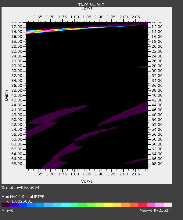
| Estimated Moho Depth: |
14.0 km |
| Estimated Crust Vp/Vs: |
1.60 |
| Assumed Crust Vp: |
6.24 km/s |
| Estimated Crust Vs: |
3.894 km/s |
| Estimated Crust Poisson's Ratio: |
0.18 |
|
| Radial Match: |
99.05094 % |
| Radial Bump: |
245 |
| Transverse Match: |
75.93506 % |
| Transverse Bump: |
341 |
| SOD ConfigId: |
11737051 |
| Insert Time: |
2019-04-26 06:13:58.230 +0000 |
| GWidth: |
2.5 |
| Max Bumps: |
400 |
| Tol: |
0.001 |
|

Signal To Noise
| Channel | StoN | STA | LTA |
| TA:O16K: :BHZ:20161208T18:14:22.199988Z | 0.79971945 | 5.6575886E-5 | 7.074467E-5 |
| TA:O16K: :BHN:20161208T18:14:22.199988Z | 2.9247844 | 1.7271162E-4 | 5.905106E-5 |
| TA:O16K: :BHE:20161208T18:14:22.199988Z | 1.4517103 | 6.138147E-5 | 4.2282176E-5 |
| Arrivals |
| Ps | 1.4 SECOND |
| PpPs | 5.7 SECOND |
| PsPs/PpSs | 7.0 SECOND |


