You are here: Home > Network List > TA - USArray Transportable Network (new EarthScope stations) Stations List
> Station P16K Nushagak River, AK, USA > Earthquake Result Viewer
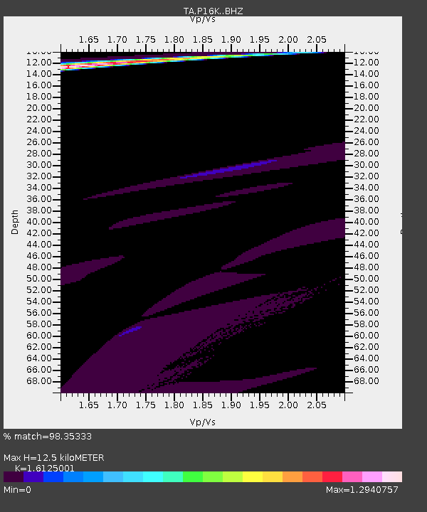
P16K Nushagak River, AK, USA - Earthquake Result Viewer
| Earthquake location: |
Solomon Islands |
| Earthquake latitude/longitude: |
-10.4/161.3 |
| Earthquake time(UTC): |
2016/12/08 (343) 18:03:05 GMT |
| Earthquake Depth: |
42 km |
| Earthquake Magnitude: |
5.6 mb |
| Earthquake Catalog/Contributor: |
NEIC PDE/us |
|
| Network: |
TA USArray Transportable Network (new EarthScope stations) |
| Station: |
P16K Nushagak River, AK, USA |
| Lat/Lon: |
59.03 N/157.99 W |
| Elevation: |
86 m |
|
| Distance: |
76.5 deg |
| Az: |
20.281 deg |
| Baz: |
221.261 deg |
| Ray Param: |
0.050849818 |
| Estimated Moho Depth: |
12.5 km |
| Estimated Crust Vp/Vs: |
1.61 |
| Assumed Crust Vp: |
6.276 km/s |
| Estimated Crust Vs: |
3.892 km/s |
| Estimated Crust Poisson's Ratio: |
0.19 |
|
| Radial Match: |
98.35333 % |
| Radial Bump: |
261 |
| Transverse Match: |
78.02315 % |
| Transverse Bump: |
400 |
| SOD ConfigId: |
11737051 |
| Insert Time: |
2019-04-26 06:14:01.281 +0000 |
| GWidth: |
2.5 |
| Max Bumps: |
400 |
| Tol: |
0.001 |
|

Signal To Noise
| Channel | StoN | STA | LTA |
| TA:P16K: :BHZ:20161208T18:14:19.999976Z | 2.37879 | 2.0717594E-4 | 8.7092994E-5 |
| TA:P16K: :BHN:20161208T18:14:19.999976Z | 0.76377624 | 1.00271965E-4 | 1.3128448E-4 |
| TA:P16K: :BHE:20161208T18:14:19.999976Z | 0.7543445 | 3.505297E-5 | 4.646812E-5 |
| Arrivals |
| Ps | 1.3 SECOND |
| PpPs | 5.0 SECOND |
| PsPs/PpSs | 6.3 SECOND |


