You are here: Home > Network List > TA - USArray Transportable Network (new EarthScope stations) Stations List
> Station Q17K Contact Creek, Katmai, AK, USA > Earthquake Result Viewer
Q17K Contact Creek, Katmai, AK, USA - Earthquake Result Viewer

| Earthquake location: |
Solomon Islands |
| Earthquake latitude/longitude: |
-10.4/161.3 |
| Earthquake time(UTC): |
2016/12/08 (343) 18:03:05 GMT |
| Earthquake Depth: |
42 km |
| Earthquake Magnitude: |
5.6 mb |
| Earthquake Catalog/Contributor: |
NEIC PDE/us |
|
| Network: |
TA USArray Transportable Network (new EarthScope stations) |
| Station: |
Q17K Contact Creek, Katmai, AK, USA |
| Lat/Lon: |
58.26 N/155.89 W |
| Elevation: |
1165 m |
|
| Distance: |
76.7 deg |
| Az: |
21.65 deg |
| Baz: |
223.371 deg |
| Ray Param: |
0.050734937 |
| Estimated Moho Depth: |
13.25 km |
| Estimated Crust Vp/Vs: |
1.60 |
| Assumed Crust Vp: |
6.438 km/s |
| Estimated Crust Vs: |
4.024 km/s |
| Estimated Crust Poisson's Ratio: |
0.18 |
|
| Radial Match: |
98.995674 % |
| Radial Bump: |
317 |
| Transverse Match: |
84.925606 % |
| Transverse Bump: |
400 |
| SOD ConfigId: |
11737051 |
| Insert Time: |
2019-04-26 06:14:04.449 +0000 |
| GWidth: |
2.5 |
| Max Bumps: |
400 |
| Tol: |
0.001 |
|
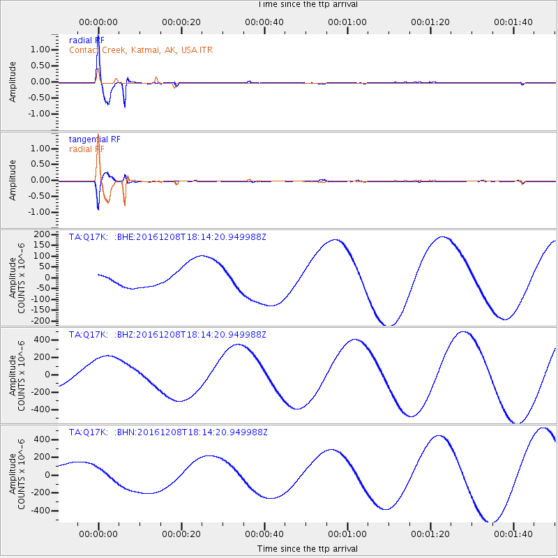
Signal To Noise
| Channel | StoN | STA | LTA |
| TA:Q17K: :BHZ:20161208T18:14:20.949988Z | 3.0419552 | 2.5665225E-4 | 8.437081E-5 |
| TA:Q17K: :BHN:20161208T18:14:20.949988Z | 0.7531865 | 7.526451E-5 | 9.992812E-5 |
| TA:Q17K: :BHE:20161208T18:14:20.949988Z | 0.9606355 | 4.5094526E-5 | 4.6942387E-5 |
| Arrivals |
| Ps | 1.3 SECOND |
| PpPs | 5.2 SECOND |
| PsPs/PpSs | 6.4 SECOND |


