You are here: Home > Network List > TA - USArray Transportable Network (new EarthScope stations) Stations List
> Station Q23K Middleton Island, AK, USA > Earthquake Result Viewer
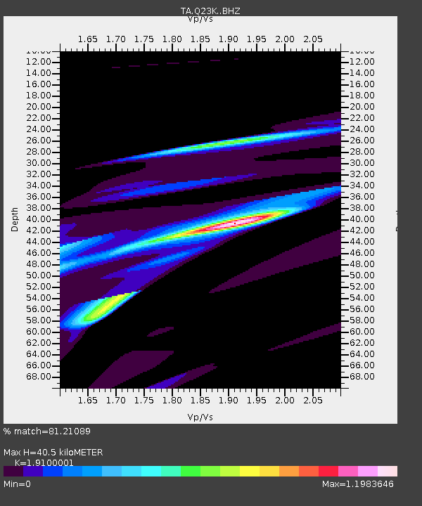
Q23K Middleton Island, AK, USA - Earthquake Result Viewer
| Earthquake location: |
Solomon Islands |
| Earthquake latitude/longitude: |
-10.4/161.3 |
| Earthquake time(UTC): |
2016/12/08 (343) 18:03:05 GMT |
| Earthquake Depth: |
42 km |
| Earthquake Magnitude: |
5.6 mb |
| Earthquake Catalog/Contributor: |
NEIC PDE/us |
|
| Network: |
TA USArray Transportable Network (new EarthScope stations) |
| Station: |
Q23K Middleton Island, AK, USA |
| Lat/Lon: |
59.43 N/146.35 W |
| Elevation: |
46 m |
|
| Distance: |
81.2 deg |
| Az: |
24.168 deg |
| Baz: |
232.006 deg |
| Ray Param: |
0.047707643 |
| Estimated Moho Depth: |
40.5 km |
| Estimated Crust Vp/Vs: |
1.91 |
| Assumed Crust Vp: |
5.989 km/s |
| Estimated Crust Vs: |
3.136 km/s |
| Estimated Crust Poisson's Ratio: |
0.31 |
|
| Radial Match: |
81.21089 % |
| Radial Bump: |
400 |
| Transverse Match: |
49.74151 % |
| Transverse Bump: |
277 |
| SOD ConfigId: |
11737051 |
| Insert Time: |
2019-04-26 06:14:05.573 +0000 |
| GWidth: |
2.5 |
| Max Bumps: |
400 |
| Tol: |
0.001 |
|

Signal To Noise
| Channel | StoN | STA | LTA |
| TA:Q23K: :BHZ:20161208T18:14:45.249976Z | 1.5060067 | 1.7015489E-5 | 1.1298414E-5 |
| TA:Q23K: :BHN:20161208T18:14:45.249976Z | 1.8571417 | 1.06718864E-4 | 5.746404E-5 |
| TA:Q23K: :BHE:20161208T18:14:45.249976Z | 1.287331 | 2.6460091E-5 | 2.0554226E-5 |
| Arrivals |
| Ps | 6.3 SECOND |
| PpPs | 19 SECOND |
| PsPs/PpSs | 26 SECOND |


