You are here: Home > Network List > TA - USArray Transportable Network (new EarthScope stations) Stations List
> Station Q18K Katmai Hardscrabble Creek, AK, USA > Earthquake Result Viewer
Q18K Katmai Hardscrabble Creek, AK, USA - Earthquake Result Viewer
| Earthquake location: |
Solomon Islands |
| Earthquake latitude/longitude: |
-10.4/161.3 |
| Earthquake time(UTC): |
2016/12/08 (343) 18:03:05 GMT |
| Earthquake Depth: |
42 km |
| Earthquake Magnitude: |
5.6 mb |
| Earthquake Catalog/Contributor: |
NEIC PDE/us |
|
| Network: |
TA USArray Transportable Network (new EarthScope stations) |
| Station: |
Q18K Katmai Hardscrabble Creek, AK, USA |
| Lat/Lon: |
58.65 N/155.01 W |
| Elevation: |
1250 m |
|
| Distance: |
77.3 deg |
| Az: |
21.718 deg |
| Baz: |
224.133 deg |
| Ray Param: |
0.050334282 |
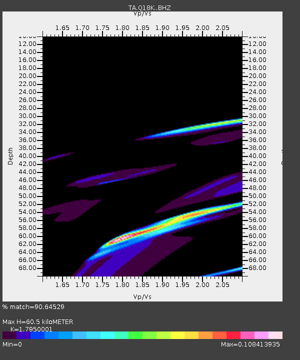
| Estimated Moho Depth: |
60.5 km |
| Estimated Crust Vp/Vs: |
1.80 |
| Assumed Crust Vp: |
6.438 km/s |
| Estimated Crust Vs: |
3.587 km/s |
| Estimated Crust Poisson's Ratio: |
0.27 |
|
| Radial Match: |
90.64529 % |
| Radial Bump: |
399 |
| Transverse Match: |
51.37556 % |
| Transverse Bump: |
400 |
| SOD ConfigId: |
11737051 |
| Insert Time: |
2019-04-26 06:14:05.695 +0000 |
| GWidth: |
2.5 |
| Max Bumps: |
400 |
| Tol: |
0.001 |
|

Signal To Noise
| Channel | StoN | STA | LTA |
| TA:Q18K: :BHZ:20161208T18:14:24.300024Z | 3.6389992 | 1.4893795E-4 | 4.0928273E-5 |
| TA:Q18K: :BHN:20161208T18:14:24.300024Z | 1.2377712 | 8.86199E-5 | 7.1596354E-5 |
| TA:Q18K: :BHE:20161208T18:14:24.300024Z | 1.2606347 | 1.7046053E-5 | 1.3521802E-5 |
| Arrivals |
| Ps | 7.7 SECOND |
| PpPs | 25 SECOND |
| PsPs/PpSs | 33 SECOND |


