You are here: Home > Network List > TA - USArray Transportable Network (new EarthScope stations) Stations List
> Station R11A Troy Canyon, Currant, NV, USA > Earthquake Result Viewer
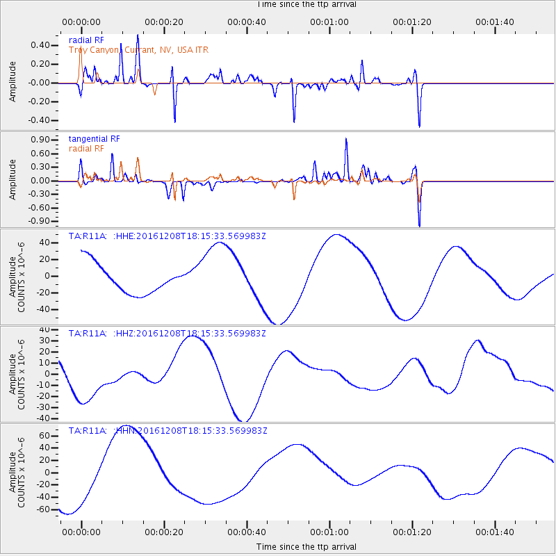
R11A Troy Canyon, Currant, NV, USA - Earthquake Result Viewer
*The percent match for this event was below the threshold and hence no stack was calculated.
| Earthquake location: |
Solomon Islands |
| Earthquake latitude/longitude: |
-10.4/161.3 |
| Earthquake time(UTC): |
2016/12/08 (343) 18:03:05 GMT |
| Earthquake Depth: |
42 km |
| Earthquake Magnitude: |
5.6 mb |
| Earthquake Catalog/Contributor: |
NEIC PDE/us |
|
| Network: |
TA USArray Transportable Network (new EarthScope stations) |
| Station: |
R11A Troy Canyon, Currant, NV, USA |
| Lat/Lon: |
38.35 N/115.59 W |
| Elevation: |
1756 m |
|
| Distance: |
91.0 deg |
| Az: |
51.323 deg |
| Baz: |
257.652 deg |
| Ray Param: |
$rayparam |
*The percent match for this event was below the threshold and hence was not used in the summary stack. |
|
| Radial Match: |
68.48235 % |
| Radial Bump: |
195 |
| Transverse Match: |
57.15406 % |
| Transverse Bump: |
181 |
| SOD ConfigId: |
11737051 |
| Insert Time: |
2019-04-26 06:14:06.947 +0000 |
| GWidth: |
2.5 |
| Max Bumps: |
400 |
| Tol: |
0.001 |
|
Signal To Noise
| Channel | StoN | STA | LTA |
| TA:R11A: :HHZ:20161208T18:15:33.569983Z | 2.448343 | 2.5806892E-5 | 1.0540554E-5 |
| TA:R11A: :HHN:20161208T18:15:33.569983Z | 1.5419397 | 3.934665E-5 | 2.5517635E-5 |
| TA:R11A: :HHE:20161208T18:15:33.569983Z | 2.3166249 | 3.943397E-5 | 1.7022165E-5 |
| Arrivals |
| Ps | |
| PpPs | |
| PsPs/PpSs | |


