You are here: Home > Network List > TA - USArray Transportable Network (new EarthScope stations) Stations List
> Station TPFO Pinon Flats, CA, USA > Earthquake Result Viewer
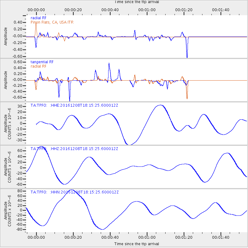
TPFO Pinon Flats, CA, USA - Earthquake Result Viewer
*The percent match for this event was below the threshold and hence no stack was calculated.
| Earthquake location: |
Solomon Islands |
| Earthquake latitude/longitude: |
-10.4/161.3 |
| Earthquake time(UTC): |
2016/12/08 (343) 18:03:05 GMT |
| Earthquake Depth: |
42 km |
| Earthquake Magnitude: |
5.6 mb |
| Earthquake Catalog/Contributor: |
NEIC PDE/us |
|
| Network: |
TA USArray Transportable Network (new EarthScope stations) |
| Station: |
TPFO Pinon Flats, CA, USA |
| Lat/Lon: |
33.61 N/116.45 W |
| Elevation: |
1275 m |
|
| Distance: |
89.3 deg |
| Az: |
55.788 deg |
| Baz: |
257.132 deg |
| Ray Param: |
$rayparam |
*The percent match for this event was below the threshold and hence was not used in the summary stack. |
|
| Radial Match: |
58.910595 % |
| Radial Bump: |
400 |
| Transverse Match: |
81.93175 % |
| Transverse Bump: |
208 |
| SOD ConfigId: |
11737051 |
| Insert Time: |
2019-04-26 06:14:11.187 +0000 |
| GWidth: |
2.5 |
| Max Bumps: |
400 |
| Tol: |
0.001 |
|
Signal To Noise
| Channel | StoN | STA | LTA |
| TA:TPFO: :HHZ:20161208T18:15:25.600012Z | 5.887959 | 8.1095604E-5 | 1.3773126E-5 |
| TA:TPFO: :HHN:20161208T18:15:25.600012Z | 1.6886823 | 5.3059022E-5 | 3.1420368E-5 |
| TA:TPFO: :HHE:20161208T18:15:25.600012Z | 0.8997385 | 6.5651566E-6 | 7.2967387E-6 |
| Arrivals |
| Ps | |
| PpPs | |
| PsPs/PpSs | |


