You are here: Home > Network List > UU - University of Utah Regional Network Stations List
> Station WPUT Wasatch Plateau, UT,USA > Earthquake Result Viewer
WPUT Wasatch Plateau, UT,USA - Earthquake Result Viewer
| Earthquake location: |
Vanuatu Islands |
| Earthquake latitude/longitude: |
-14.8/167.3 |
| Earthquake time(UTC): |
2015/10/20 (293) 21:52:02 GMT |
| Earthquake Depth: |
127 km |
| Earthquake Magnitude: |
7.1 MWW, 7.3 MI |
| Earthquake Catalog/Contributor: |
NEIC PDE/NEIC COMCAT |
|
| Network: |
UU University of Utah Regional Network |
| Station: |
WPUT Wasatch Plateau, UT,USA |
| Lat/Lon: |
39.00 N/111.36 W |
| Elevation: |
2618 m |
|
| Distance: |
92.6 deg |
| Az: |
50.458 deg |
| Baz: |
253.144 deg |
| Ray Param: |
0.041347858 |
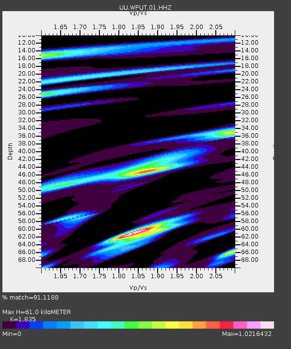
| Estimated Moho Depth: |
61.0 km |
| Estimated Crust Vp/Vs: |
1.84 |
| Assumed Crust Vp: |
6.207 km/s |
| Estimated Crust Vs: |
3.382 km/s |
| Estimated Crust Poisson's Ratio: |
0.29 |
|
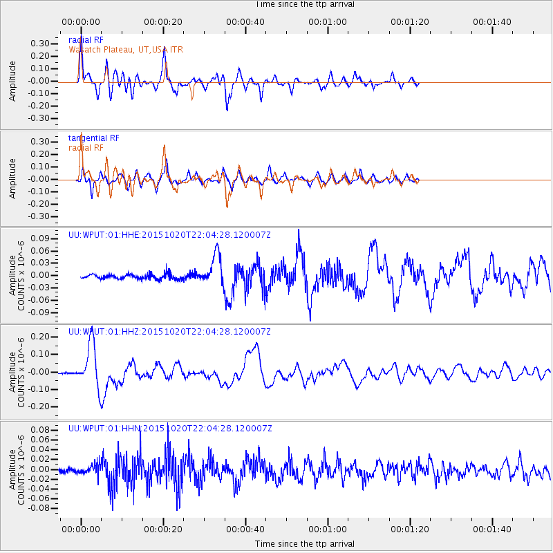
| Radial Match: |
91.1188 % |
| Radial Bump: |
400 |
| Transverse Match: |
85.90726 % |
| Transverse Bump: |
400 |
| SOD ConfigId: |
1259291 |
| Insert Time: |
2015-11-03 22:25:11.287 +0000 |
| GWidth: |
2.5 |
| Max Bumps: |
400 |
| Tol: |
0.001 |
|
Signal To Noise
| Channel | StoN | STA | LTA |
| UU:WPUT:01:HHZ:20151020T22:04:28.120007Z | 41.0946 | 1.2857605E-7 | 3.1287821E-9 |
| UU:WPUT:01:HHN:20151020T22:04:28.120007Z | 2.5262413 | 9.785953E-9 | 3.8737205E-9 |
| UU:WPUT:01:HHE:20151020T22:04:28.120007Z | 6.7044106 | 3.8320326E-8 | 5.7156893E-9 |
| Arrivals |
| Ps | 8.4 SECOND |
| PpPs | 27 SECOND |
| PsPs/PpSs | 36 SECOND |


