You are here: Home > Network List > WY - Yellowstone Wyoming Seismic Network Stations List
> Station YHH Holmes Hill, YNP, WY, USA > Earthquake Result Viewer
YHH Holmes Hill, YNP, WY, USA - Earthquake Result Viewer

| Earthquake location: |
Vanuatu Islands |
| Earthquake latitude/longitude: |
-14.8/167.3 |
| Earthquake time(UTC): |
2015/10/20 (293) 21:52:02 GMT |
| Earthquake Depth: |
127 km |
| Earthquake Magnitude: |
7.1 MWW, 7.3 MI |
| Earthquake Catalog/Contributor: |
NEIC PDE/NEIC COMCAT |
|
| Network: |
WY Yellowstone Wyoming Seismic Network |
| Station: |
YHH Holmes Hill, YNP, WY, USA |
| Lat/Lon: |
44.79 N/110.85 W |
| Elevation: |
2717 m |
|
| Distance: |
94.6 deg |
| Az: |
45.007 deg |
| Baz: |
253.829 deg |
| Ray Param: |
0.04089777 |
| Estimated Moho Depth: |
21.25 km |
| Estimated Crust Vp/Vs: |
2.10 |
| Assumed Crust Vp: |
6.35 km/s |
| Estimated Crust Vs: |
3.027 km/s |
| Estimated Crust Poisson's Ratio: |
0.35 |
|
| Radial Match: |
94.08759 % |
| Radial Bump: |
315 |
| Transverse Match: |
90.83063 % |
| Transverse Bump: |
344 |
| SOD ConfigId: |
1259291 |
| Insert Time: |
2015-11-03 22:25:28.175 +0000 |
| GWidth: |
2.5 |
| Max Bumps: |
400 |
| Tol: |
0.001 |
|
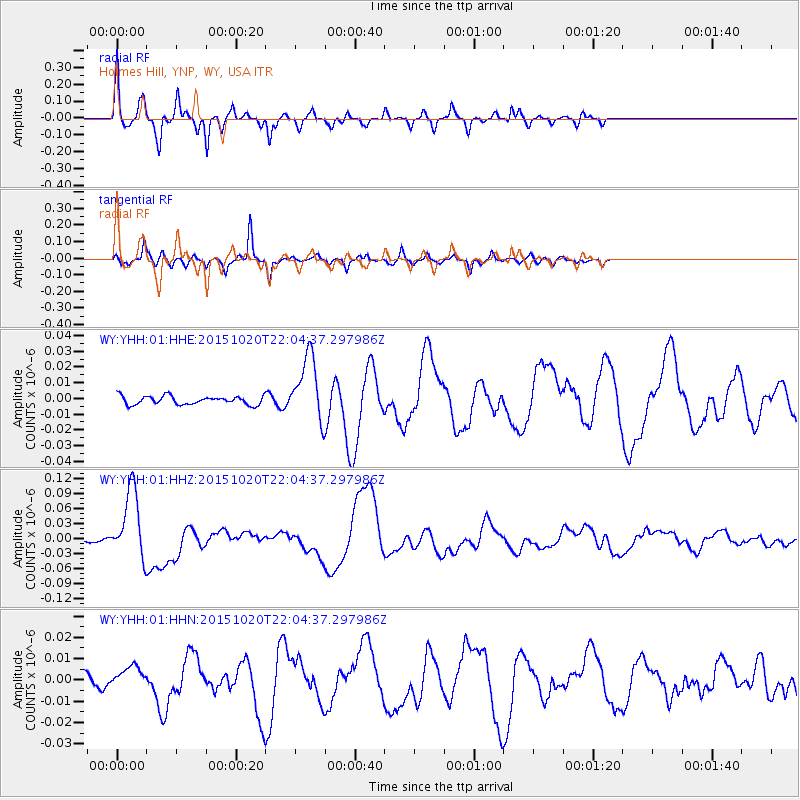
Signal To Noise
| Channel | StoN | STA | LTA |
| WY:YHH:01:HHZ:20151020T22:04:37.297986Z | 28.990969 | 6.871378E-8 | 2.370179E-9 |
| WY:YHH:01:HHN:20151020T22:04:37.297986Z | 1.9687928 | 4.971782E-9 | 2.5252949E-9 |
| WY:YHH:01:HHE:20151020T22:04:37.297986Z | 7.694921 | 2.050163E-8 | 2.6643068E-9 |
| Arrivals |
| Ps | 3.7 SECOND |
| PpPs | 10 SECOND |
| PsPs/PpSs | 14 SECOND |


