You are here: Home > Network List > TA - USArray Transportable Network (new EarthScope stations) Stations List
> Station G23K Bananza Creek, AK, USA > Earthquake Result Viewer
G23K Bananza Creek, AK, USA - Earthquake Result Viewer
| Earthquake location: |
Solomon Islands |
| Earthquake latitude/longitude: |
-10.9/161.2 |
| Earthquake time(UTC): |
2016/12/08 (343) 21:48:33 GMT |
| Earthquake Depth: |
21 km |
| Earthquake Magnitude: |
5.5 mb |
| Earthquake Catalog/Contributor: |
NEIC PDE/us |
|
| Network: |
TA USArray Transportable Network (new EarthScope stations) |
| Station: |
G23K Bananza Creek, AK, USA |
| Lat/Lon: |
66.71 N/150.02 W |
| Elevation: |
746 m |
|
| Distance: |
85.1 deg |
| Az: |
17.469 deg |
| Baz: |
227.863 deg |
| Ray Param: |
0.04497483 |
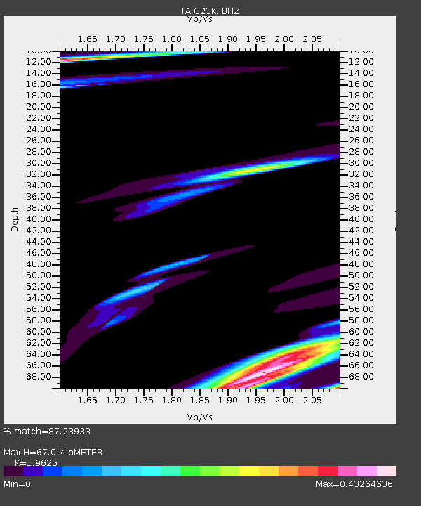
| Estimated Moho Depth: |
67.0 km |
| Estimated Crust Vp/Vs: |
1.96 |
| Assumed Crust Vp: |
6.577 km/s |
| Estimated Crust Vs: |
3.351 km/s |
| Estimated Crust Poisson's Ratio: |
0.32 |
|
| Radial Match: |
87.23933 % |
| Radial Bump: |
371 |
| Transverse Match: |
68.252266 % |
| Transverse Bump: |
379 |
| SOD ConfigId: |
11737051 |
| Insert Time: |
2019-04-26 06:27:57.937 +0000 |
| GWidth: |
2.5 |
| Max Bumps: |
400 |
| Tol: |
0.001 |
|

Signal To Noise
| Channel | StoN | STA | LTA |
| TA:G23K: :BHZ:20161208T22:00:35.774976Z | 2.0602357 | 1.0253259E-6 | 4.97674E-7 |
| TA:G23K: :BHN:20161208T22:00:35.774976Z | 0.71397156 | 4.7723336E-7 | 6.684207E-7 |
| TA:G23K: :BHE:20161208T22:00:35.774976Z | 2.7213619 | 9.014778E-7 | 3.3125977E-7 |
| Arrivals |
| Ps | 10 SECOND |
| PpPs | 29 SECOND |
| PsPs/PpSs | 40 SECOND |


