You are here: Home > Network List > TA - USArray Transportable Network (new EarthScope stations) Stations List
> Station L27K Beaver Creek, Northway Junction, AK, USA > Earthquake Result Viewer
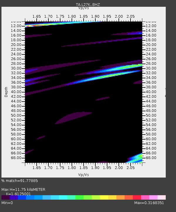
L27K Beaver Creek, Northway Junction, AK, USA - Earthquake Result Viewer
| Earthquake location: |
Solomon Islands |
| Earthquake latitude/longitude: |
-10.9/161.2 |
| Earthquake time(UTC): |
2016/12/08 (343) 21:48:33 GMT |
| Earthquake Depth: |
21 km |
| Earthquake Magnitude: |
5.5 mb |
| Earthquake Catalog/Contributor: |
NEIC PDE/us |
|
| Network: |
TA USArray Transportable Network (new EarthScope stations) |
| Station: |
L27K Beaver Creek, Northway Junction, AK, USA |
| Lat/Lon: |
63.06 N/141.83 W |
| Elevation: |
755 m |
|
| Distance: |
85.6 deg |
| Az: |
22.521 deg |
| Baz: |
235.691 deg |
| Ray Param: |
0.044626858 |
| Estimated Moho Depth: |
11.75 km |
| Estimated Crust Vp/Vs: |
1.61 |
| Assumed Crust Vp: |
6.566 km/s |
| Estimated Crust Vs: |
4.072 km/s |
| Estimated Crust Poisson's Ratio: |
0.19 |
|
| Radial Match: |
91.77885 % |
| Radial Bump: |
400 |
| Transverse Match: |
86.58264 % |
| Transverse Bump: |
400 |
| SOD ConfigId: |
11737051 |
| Insert Time: |
2019-04-26 06:28:04.004 +0000 |
| GWidth: |
2.5 |
| Max Bumps: |
400 |
| Tol: |
0.001 |
|

Signal To Noise
| Channel | StoN | STA | LTA |
| TA:L27K: :BHZ:20161208T22:00:38.175Z | 2.1218934 | 1.5694121E-6 | 7.396282E-7 |
| TA:L27K: :BHN:20161208T22:00:38.175Z | 1.269122 | 1.010205E-6 | 7.959873E-7 |
| TA:L27K: :BHE:20161208T22:00:38.175Z | 0.7581712 | 3.0026473E-7 | 3.960382E-7 |
| Arrivals |
| Ps | 1.1 SECOND |
| PpPs | 4.5 SECOND |
| PsPs/PpSs | 5.7 SECOND |


