You are here: Home > Network List > TA - USArray Transportable Network (new EarthScope stations) Stations List
> Station O17K Koliganek, Bristol Bay, AK, USA > Earthquake Result Viewer
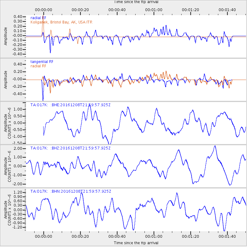
O17K Koliganek, Bristol Bay, AK, USA - Earthquake Result Viewer
*The percent match for this event was below the threshold and hence no stack was calculated.
| Earthquake location: |
Solomon Islands |
| Earthquake latitude/longitude: |
-10.9/161.2 |
| Earthquake time(UTC): |
2016/12/08 (343) 21:48:33 GMT |
| Earthquake Depth: |
21 km |
| Earthquake Magnitude: |
5.5 mb |
| Earthquake Catalog/Contributor: |
NEIC PDE/us |
|
| Network: |
TA USArray Transportable Network (new EarthScope stations) |
| Station: |
O17K Koliganek, Bristol Bay, AK, USA |
| Lat/Lon: |
59.77 N/157.09 W |
| Elevation: |
156 m |
|
| Distance: |
77.9 deg |
| Az: |
20.137 deg |
| Baz: |
221.939 deg |
| Ray Param: |
$rayparam |
*The percent match for this event was below the threshold and hence was not used in the summary stack. |
|
| Radial Match: |
68.278984 % |
| Radial Bump: |
400 |
| Transverse Match: |
68.60426 % |
| Transverse Bump: |
400 |
| SOD ConfigId: |
11737051 |
| Insert Time: |
2019-04-26 06:28:08.392 +0000 |
| GWidth: |
2.5 |
| Max Bumps: |
400 |
| Tol: |
0.001 |
|
Signal To Noise
| Channel | StoN | STA | LTA |
| TA:O17K: :BHZ:20161208T21:59:57.925Z | 0.60902685 | 3.2489234E-7 | 5.334614E-7 |
| TA:O17K: :BHN:20161208T21:59:57.925Z | 2.0524232 | 7.6143283E-7 | 3.7099213E-7 |
| TA:O17K: :BHE:20161208T21:59:57.925Z | 1.4819373 | 8.905268E-7 | 6.009207E-7 |
| Arrivals |
| Ps | |
| PpPs | |
| PsPs/PpSs | |


