You are here: Home > Network List > TA - USArray Transportable Network (new EarthScope stations) Stations List
> Station R11A Troy Canyon, Currant, NV, USA > Earthquake Result Viewer
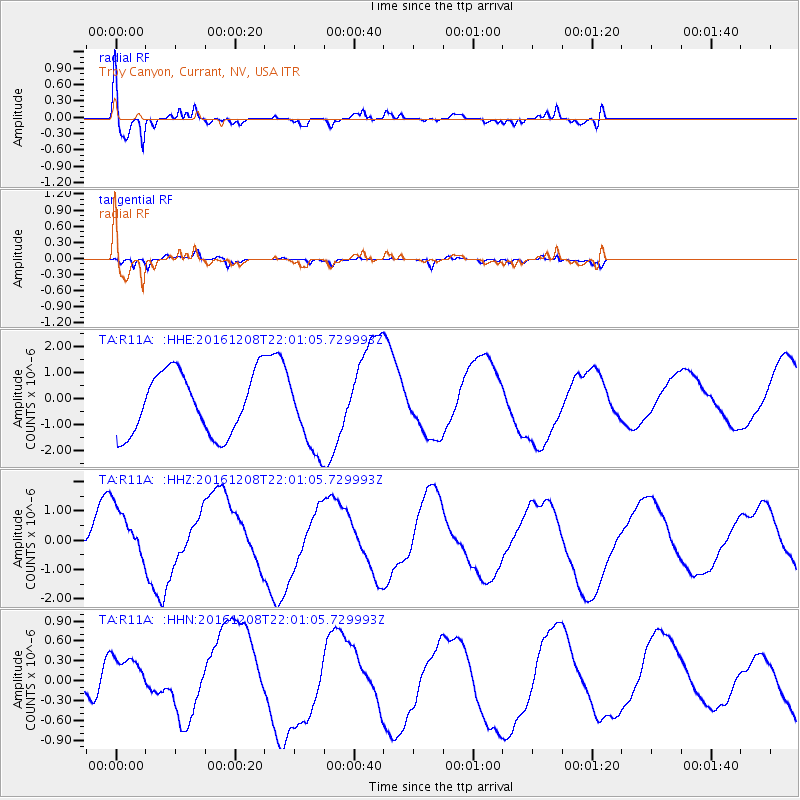
R11A Troy Canyon, Currant, NV, USA - Earthquake Result Viewer
*The percent match for this event was below the threshold and hence no stack was calculated.
| Earthquake location: |
Solomon Islands |
| Earthquake latitude/longitude: |
-10.9/161.2 |
| Earthquake time(UTC): |
2016/12/08 (343) 21:48:33 GMT |
| Earthquake Depth: |
21 km |
| Earthquake Magnitude: |
5.5 mb |
| Earthquake Catalog/Contributor: |
NEIC PDE/us |
|
| Network: |
TA USArray Transportable Network (new EarthScope stations) |
| Station: |
R11A Troy Canyon, Currant, NV, USA |
| Lat/Lon: |
38.35 N/115.59 W |
| Elevation: |
1756 m |
|
| Distance: |
91.4 deg |
| Az: |
51.354 deg |
| Baz: |
257.334 deg |
| Ray Param: |
$rayparam |
*The percent match for this event was below the threshold and hence was not used in the summary stack. |
|
| Radial Match: |
70.658806 % |
| Radial Bump: |
400 |
| Transverse Match: |
91.84062 % |
| Transverse Bump: |
306 |
| SOD ConfigId: |
11737051 |
| Insert Time: |
2019-04-26 06:28:13.026 +0000 |
| GWidth: |
2.5 |
| Max Bumps: |
400 |
| Tol: |
0.001 |
|
Signal To Noise
| Channel | StoN | STA | LTA |
| TA:R11A: :HHZ:20161208T22:01:05.729993Z | 1.5022155 | 9.74331E-7 | 6.4859603E-7 |
| TA:R11A: :HHN:20161208T22:01:05.729993Z | 2.272595 | 3.708505E-7 | 1.6318373E-7 |
| TA:R11A: :HHE:20161208T22:01:05.729993Z | 1.29828 | 1.5457648E-6 | 1.1906251E-6 |
| Arrivals |
| Ps | |
| PpPs | |
| PsPs/PpSs | |


