You are here: Home > Network List > CI - Caltech Regional Seismic Network Stations List
> Station MPM Manuel Prospect Mine, California, USA > Earthquake Result Viewer
MPM Manuel Prospect Mine, California, USA - Earthquake Result Viewer
| Earthquake location: |
New Ireland Region, P.N.G. |
| Earthquake latitude/longitude: |
-5.2/153.1 |
| Earthquake time(UTC): |
2000/11/16 (321) 08:12:20 GMT |
| Earthquake Depth: |
33 km |
| Earthquake Magnitude: |
5.5 MB |
| Earthquake Catalog/Contributor: |
WHDF/NEIC |
|
| Network: |
CI Caltech Regional Seismic Network |
| Station: |
MPM Manuel Prospect Mine, California, USA |
| Lat/Lon: |
36.06 N/117.49 W |
| Elevation: |
185 m |
|
| Distance: |
92.5 deg |
| Az: |
54.198 deg |
| Baz: |
265.422 deg |
| Ray Param: |
0.041428708 |
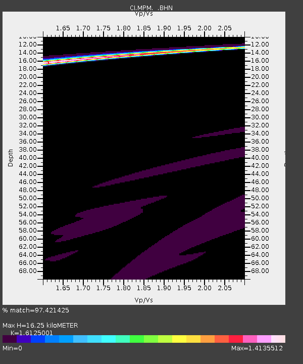
| Estimated Moho Depth: |
16.25 km |
| Estimated Crust Vp/Vs: |
1.61 |
| Assumed Crust Vp: |
6.279 km/s |
| Estimated Crust Vs: |
3.894 km/s |
| Estimated Crust Poisson's Ratio: |
0.19 |
|
| Radial Match: |
97.421425 % |
| Radial Bump: |
195 |
| Transverse Match: |
55.308064 % |
| Transverse Bump: |
400 |
| SOD ConfigId: |
3770 |
| Insert Time: |
2010-03-05 20:23:41.034 +0000 |
| GWidth: |
2.5 |
| Max Bumps: |
400 |
| Tol: |
0.001 |
|
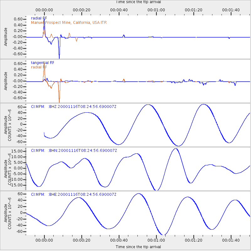
Signal To Noise
| Channel | StoN | STA | LTA |
| CI:MPM: :BHN:20001116T08:24:56.690007Z | 0.9518204 | 7.4714662E-6 | 7.84966E-6 |
| CI:MPM: :BHE:20001116T08:24:56.690007Z | 2.6305761 | 4.5126875E-5 | 1.7154749E-5 |
| CI:MPM: :BHZ:20001116T08:24:56.690007Z | 0.64208186 | 2.1824208E-5 | 3.398976E-5 |
| Arrivals |
| Ps | 1.6 SECOND |
| PpPs | 6.6 SECOND |
| PsPs/PpSs | 8.2 SECOND |


