You are here: Home > Network List > CI - Caltech Regional Seismic Network Stations List
> Station MPM Manuel Prospect Mine, California, USA > Earthquake Result Viewer
MPM Manuel Prospect Mine, California, USA - Earthquake Result Viewer
| Earthquake location: |
Northern Mid-Atlantic Ridge |
| Earthquake latitude/longitude: |
31.7/-41.0 |
| Earthquake time(UTC): |
2000/10/05 (279) 13:39:11 GMT |
| Earthquake Depth: |
10 km |
| Earthquake Magnitude: |
5.4 MB, 6.1 MS, 6.0 MW, 5.9 MW |
| Earthquake Catalog/Contributor: |
WHDF/NEIC |
|
| Network: |
CI Caltech Regional Seismic Network |
| Station: |
MPM Manuel Prospect Mine, California, USA |
| Lat/Lon: |
36.06 N/117.49 W |
| Elevation: |
185 m |
|
| Distance: |
62.1 deg |
| Az: |
296.945 deg |
| Baz: |
69.623 deg |
| Ray Param: |
0.06043318 |
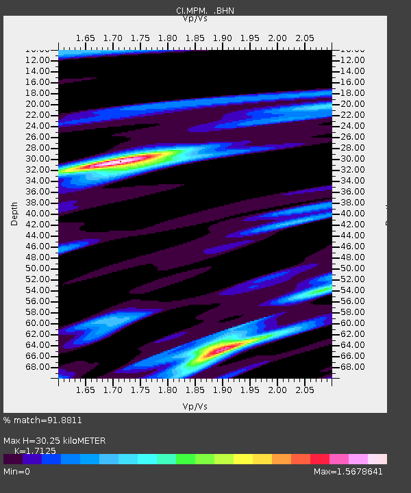
| Estimated Moho Depth: |
30.25 km |
| Estimated Crust Vp/Vs: |
1.71 |
| Assumed Crust Vp: |
6.279 km/s |
| Estimated Crust Vs: |
3.666 km/s |
| Estimated Crust Poisson's Ratio: |
0.24 |
|
| Radial Match: |
91.8811 % |
| Radial Bump: |
325 |
| Transverse Match: |
68.71764 % |
| Transverse Bump: |
373 |
| SOD ConfigId: |
3770 |
| Insert Time: |
2010-03-05 20:23:50.898 +0000 |
| GWidth: |
2.5 |
| Max Bumps: |
400 |
| Tol: |
0.001 |
|
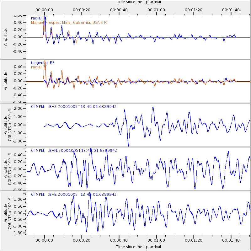
Signal To Noise
| Channel | StoN | STA | LTA |
| CI:MPM: :BHN:20001005T13:49:01.638994Z | 0.45048183 | 6.32945E-8 | 1.40504E-7 |
| CI:MPM: :BHE:20001005T13:49:01.638994Z | 0.72336054 | 1.1776885E-7 | 1.6280795E-7 |
| CI:MPM: :BHZ:20001005T13:49:01.638994Z | 0.7960485 | 1.3397691E-7 | 1.6830244E-7 |
| Arrivals |
| Ps | 3.6 SECOND |
| PpPs | 13 SECOND |
| PsPs/PpSs | 16 SECOND |


