You are here: Home > Network List > CI - Caltech Regional Seismic Network Stations List
> Station MPM Manuel Prospect Mine, California, USA > Earthquake Result Viewer
MPM Manuel Prospect Mine, California, USA - Earthquake Result Viewer
| Earthquake location: |
Off Coast Of Costa Rica |
| Earthquake latitude/longitude: |
9.4/-85.3 |
| Earthquake time(UTC): |
2000/07/21 (203) 01:53:35 GMT |
| Earthquake Depth: |
33 km |
| Earthquake Magnitude: |
5.9 MB, 6.1 MS, 6.4 MW, 5.7 ML |
| Earthquake Catalog/Contributor: |
WHDF/NEIC |
|
| Network: |
CI Caltech Regional Seismic Network |
| Station: |
MPM Manuel Prospect Mine, California, USA |
| Lat/Lon: |
36.06 N/117.49 W |
| Elevation: |
185 m |
|
| Distance: |
39.5 deg |
| Az: |
317.259 deg |
| Baz: |
124.265 deg |
| Ray Param: |
0.0749098 |
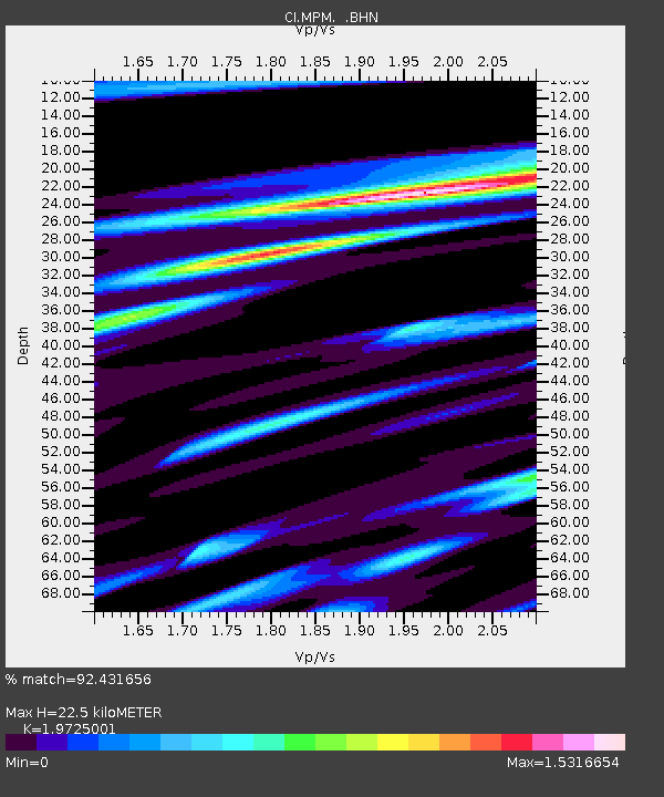
| Estimated Moho Depth: |
22.5 km |
| Estimated Crust Vp/Vs: |
1.97 |
| Assumed Crust Vp: |
6.279 km/s |
| Estimated Crust Vs: |
3.183 km/s |
| Estimated Crust Poisson's Ratio: |
0.33 |
|
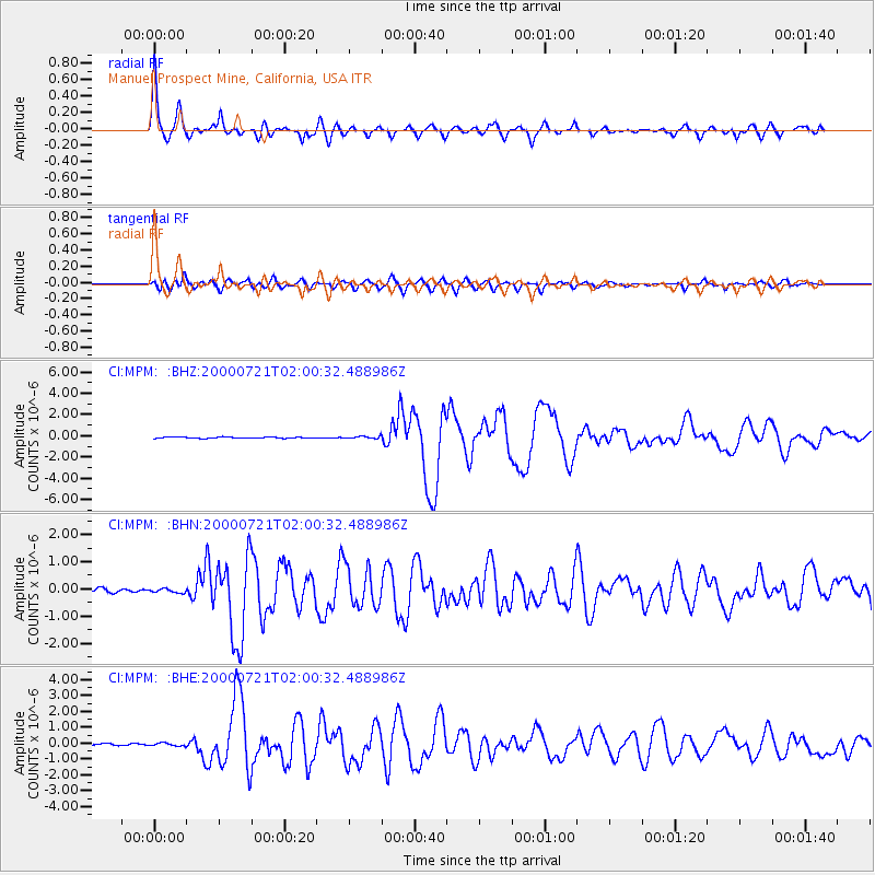
| Radial Match: |
92.431656 % |
| Radial Bump: |
400 |
| Transverse Match: |
83.54862 % |
| Transverse Bump: |
400 |
| SOD ConfigId: |
3770 |
| Insert Time: |
2010-03-05 20:23:54.370 +0000 |
| GWidth: |
2.5 |
| Max Bumps: |
400 |
| Tol: |
0.001 |
|
Signal To Noise
| Channel | StoN | STA | LTA |
| CI:MPM: :BHN:20000721T02:00:32.488986Z | 0.94457126 | 6.717224E-8 | 7.1113995E-8 |
| CI:MPM: :BHE:20000721T02:00:32.488986Z | 1.2727426 | 9.0279194E-8 | 7.093279E-8 |
| CI:MPM: :BHZ:20000721T02:00:32.488986Z | 1.9019889 | 1.1135473E-7 | 5.854647E-8 |
| Arrivals |
| Ps | 3.7 SECOND |
| PpPs | 10 SECOND |
| PsPs/PpSs | 14 SECOND |


