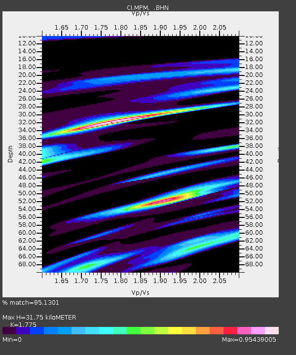
MPM Manuel Prospect Mine, California, USA - Earthquake Result Viewer
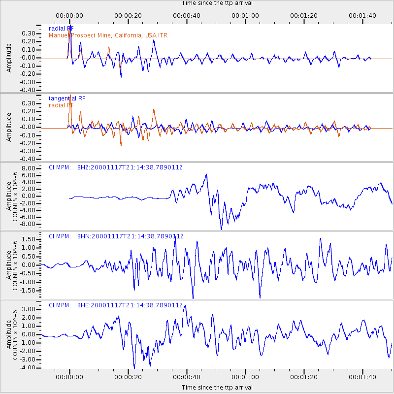
Earthquake location: New Britain Region, P.N.G.
Earthquake latitude/longitude: -5.5/151.8
Earthquake time(UTC): 2000/11/17 (322) 21:01:56 GMT
Earthquake Depth: 33 km
Earthquake Magnitude: 6.2 MB, 8.0 MS, 7.6 MW, 6.9 ME
Earthquake Catalog/Contributor: WHDF/NEIC
Network: CI Caltech Regional Seismic Network
Station: MPM Manuel Prospect Mine, California, USA
Lat/Lon: 36.06 N/117.49 W
Elevation: 185 m
Distance: 93.8 deg
Az: 54.292 deg
Baz: 265.997 deg
Ray Param: 0.041181017
Estimated Moho Depth: 31.75 km
Estimated Crust Vp/Vs: 1.77
Assumed Crust Vp: 6.279 km/s
Estimated Crust Vs: 3.537 km/s
Estimated Crust Poisson's Ratio: 0.27
Radial Match: 95.1301 %
Radial Bump: 400
Transverse Match: 73.60972 %
Transverse Bump: 400
SOD ConfigId: 3787
Insert Time: 2010-03-05 20:24:12.425 +0000
GWidth: 2.5
Max Bumps: 400
Tol: 0.001

Signal To Noise

ChannelStoNSTALTA
CI:MPM: :BHN:20001117T21:14:38.789011Z0.50723417.343542E-81.447762E-7
CI:MPM: :BHE:20001117T21:14:38.789011Z1.23965781.6786295E-71.3541072E-7
CI:MPM: :BHZ:20001117T21:14:38.789011Z1.58720733.6667214E-72.3101717E-7
Arrivals
Ps4.0 SECOND
PpPs14 SECOND
PsPs/PpSs18 SECOND