You are here: Home > Network List > CI - Caltech Regional Seismic Network Stations List
> Station MPM Manuel Prospect Mine, California, USA > Earthquake Result Viewer
MPM Manuel Prospect Mine, California, USA - Earthquake Result Viewer
| Earthquake location: |
Near Coast Of Ecuador |
| Earthquake latitude/longitude: |
-0.2/-80.6 |
| Earthquake time(UTC): |
2000/09/28 (272) 23:23:43 GMT |
| Earthquake Depth: |
23 km |
| Earthquake Magnitude: |
5.8 MB, 6.0 MS, 6.6 MW, 6.4 MW |
| Earthquake Catalog/Contributor: |
WHDF/NEIC |
|
| Network: |
CI Caltech Regional Seismic Network |
| Station: |
MPM Manuel Prospect Mine, California, USA |
| Lat/Lon: |
36.06 N/117.49 W |
| Elevation: |
185 m |
|
| Distance: |
49.8 deg |
| Az: |
320.411 deg |
| Baz: |
128.144 deg |
| Ray Param: |
0.068450265 |
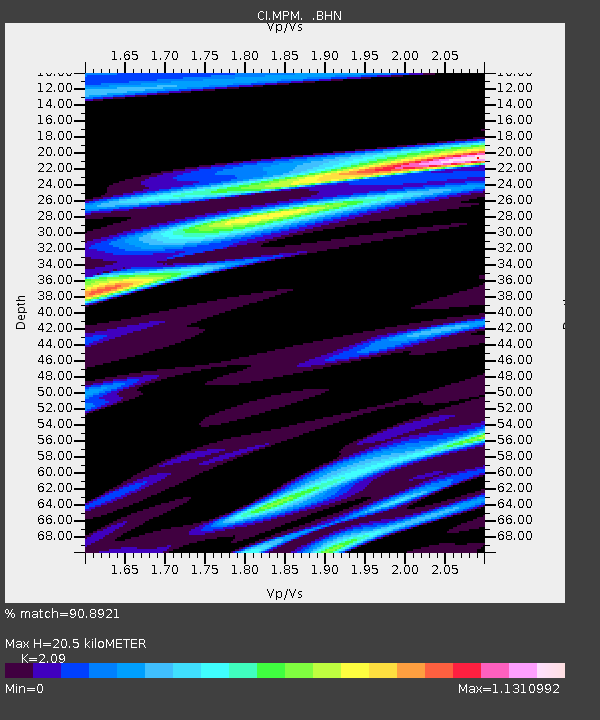
| Estimated Moho Depth: |
20.5 km |
| Estimated Crust Vp/Vs: |
2.09 |
| Assumed Crust Vp: |
6.279 km/s |
| Estimated Crust Vs: |
3.004 km/s |
| Estimated Crust Poisson's Ratio: |
0.35 |
|
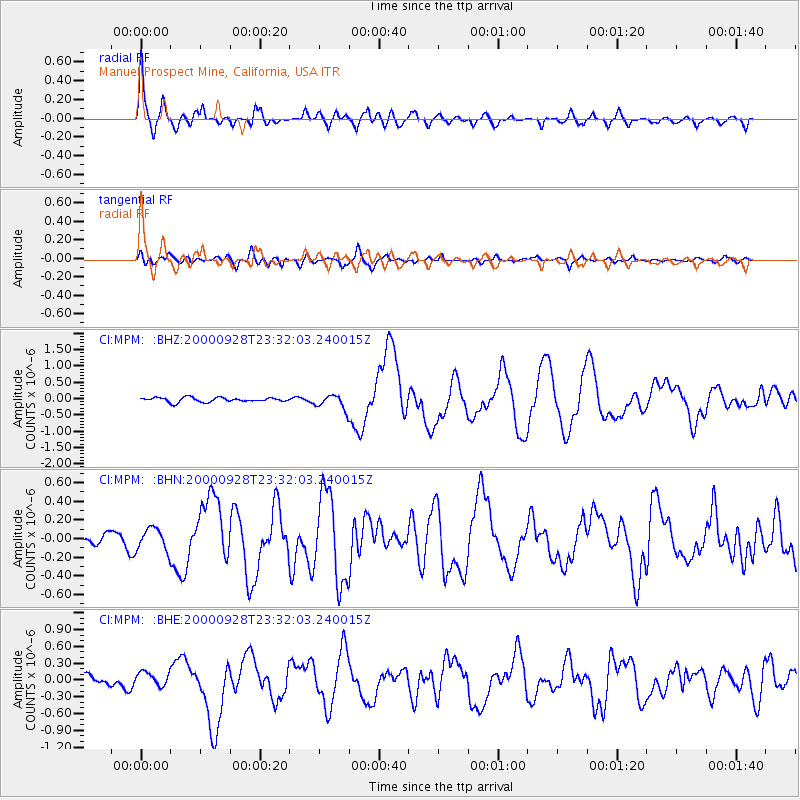
| Radial Match: |
90.8921 % |
| Radial Bump: |
400 |
| Transverse Match: |
73.373886 % |
| Transverse Bump: |
400 |
| SOD ConfigId: |
3787 |
| Insert Time: |
2010-03-05 20:24:28.307 +0000 |
| GWidth: |
2.5 |
| Max Bumps: |
400 |
| Tol: |
0.001 |
|
Signal To Noise
| Channel | StoN | STA | LTA |
| CI:MPM: :BHN:20000928T23:32:03.240015Z | 1.7101197 | 1.194602E-7 | 6.985487E-8 |
| CI:MPM: :BHE:20000928T23:32:03.240015Z | 1.5264381 | 1.2707336E-7 | 8.324829E-8 |
| CI:MPM: :BHZ:20000928T23:32:03.240015Z | 3.2500465 | 2.2095801E-7 | 6.798611E-8 |
| Arrivals |
| Ps | 3.7 SECOND |
| PpPs | 9.6 SECOND |
| PsPs/PpSs | 13 SECOND |


