You are here: Home > Network List > YT07 - POLENET Stations List
> Station THUR THUR > Earthquake Result Viewer
THUR THUR - Earthquake Result Viewer
| Earthquake location: |
Solomon Islands |
| Earthquake latitude/longitude: |
-10.8/161.3 |
| Earthquake time(UTC): |
2016/12/08 (343) 21:56:07 GMT |
| Earthquake Depth: |
15 km |
| Earthquake Magnitude: |
6.5 Mww |
| Earthquake Catalog/Contributor: |
NEIC PDE/us |
|
| Network: |
YT POLENET |
| Station: |
THUR THUR |
| Lat/Lon: |
72.53 S/97.56 W |
| Elevation: |
239 m |
|
| Distance: |
83.1 deg |
| Az: |
162.63 deg |
| Baz: |
256.173 deg |
| Ray Param: |
0.046438064 |
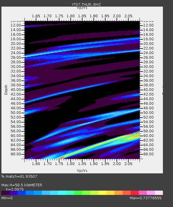
| Estimated Moho Depth: |
58.5 km |
| Estimated Crust Vp/Vs: |
2.09 |
| Assumed Crust Vp: |
6.43 km/s |
| Estimated Crust Vs: |
3.08 km/s |
| Estimated Crust Poisson's Ratio: |
0.35 |
|
| Radial Match: |
81.93507 % |
| Radial Bump: |
400 |
| Transverse Match: |
68.89569 % |
| Transverse Bump: |
400 |
| SOD ConfigId: |
11737051 |
| Insert Time: |
2019-04-26 06:35:41.522 +0000 |
| GWidth: |
2.5 |
| Max Bumps: |
400 |
| Tol: |
0.001 |
|

Signal To Noise
| Channel | StoN | STA | LTA |
| YT:THUR: :BHZ:20161208T22:08:01.250027Z | 4.1667323 | 1.2146999E-6 | 2.9152338E-7 |
| YT:THUR: :BHN:20161208T22:08:01.250027Z | 0.6281452 | 1.5894608E-7 | 2.5304033E-7 |
| YT:THUR: :BHE:20161208T22:08:01.250027Z | 3.16039 | 6.901214E-7 | 2.1836591E-7 |
| Arrivals |
| Ps | 10 SECOND |
| PpPs | 27 SECOND |
| PsPs/PpSs | 38 SECOND |


