You are here: Home > Network List > CI - Caltech Regional Seismic Network Stations List
> Station MPM Manuel Prospect Mine, California, USA > Earthquake Result Viewer
MPM Manuel Prospect Mine, California, USA - Earthquake Result Viewer
| Earthquake location: |
Sakhalin, Russia |
| Earthquake latitude/longitude: |
48.8/142.2 |
| Earthquake time(UTC): |
2000/08/04 (217) 21:13:02 GMT |
| Earthquake Depth: |
10 km |
| Earthquake Magnitude: |
6.3 MB, 7.1 MS, 6.8 MW, 6.7 MW |
| Earthquake Catalog/Contributor: |
WHDF/NEIC |
|
| Network: |
CI Caltech Regional Seismic Network |
| Station: |
MPM Manuel Prospect Mine, California, USA |
| Lat/Lon: |
36.06 N/117.49 W |
| Elevation: |
185 m |
|
| Distance: |
69.9 deg |
| Az: |
58.121 deg |
| Baz: |
316.124 deg |
| Ray Param: |
0.055355433 |
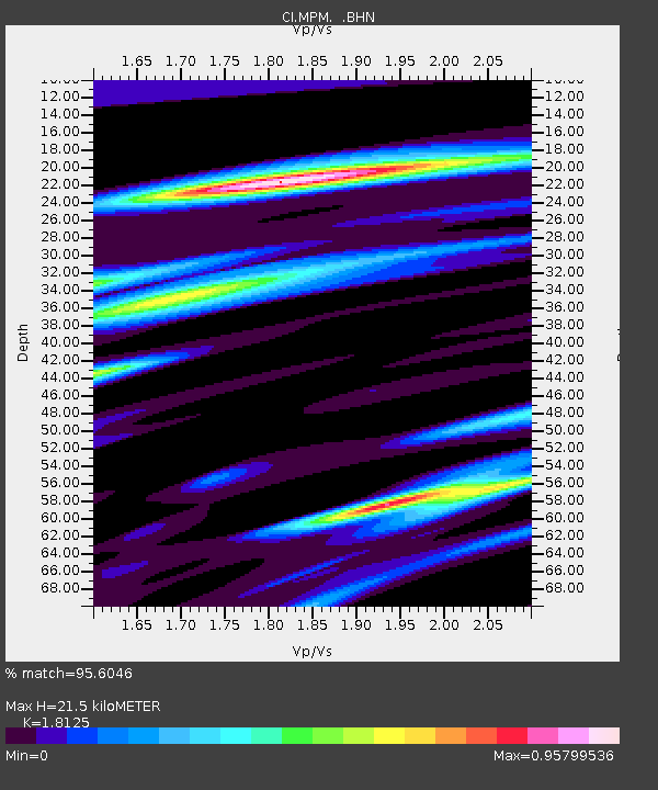
| Estimated Moho Depth: |
21.5 km |
| Estimated Crust Vp/Vs: |
1.81 |
| Assumed Crust Vp: |
6.279 km/s |
| Estimated Crust Vs: |
3.464 km/s |
| Estimated Crust Poisson's Ratio: |
0.28 |
|
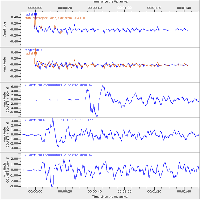
| Radial Match: |
95.6046 % |
| Radial Bump: |
400 |
| Transverse Match: |
88.64984 % |
| Transverse Bump: |
400 |
| SOD ConfigId: |
3787 |
| Insert Time: |
2010-03-05 20:24:44.295 +0000 |
| GWidth: |
2.5 |
| Max Bumps: |
400 |
| Tol: |
0.001 |
|
Signal To Noise
| Channel | StoN | STA | LTA |
| CI:MPM: :BHN:20000804T21:23:42.389016Z | 6.8049426 | 4.727462E-7 | 6.947101E-8 |
| CI:MPM: :BHE:20000804T21:23:42.389016Z | 5.630863 | 4.1032075E-7 | 7.286995E-8 |
| CI:MPM: :BHZ:20000804T21:23:42.389016Z | 19.207596 | 1.5533606E-6 | 8.0872205E-8 |
| Arrivals |
| Ps | 2.9 SECOND |
| PpPs | 9.3 SECOND |
| PsPs/PpSs | 12 SECOND |


