You are here: Home > Network List > CI - Caltech Regional Seismic Network Stations List
> Station SDD Saddleback, Mission Viejo, CA, USA > Earthquake Result Viewer
SDD Saddleback, Mission Viejo, CA, USA - Earthquake Result Viewer
| Earthquake location: |
Northwest Of Kuril Islands |
| Earthquake latitude/longitude: |
47.8/146.2 |
| Earthquake time(UTC): |
2002/11/17 (321) 04:53:53 GMT |
| Earthquake Depth: |
459 km |
| Earthquake Magnitude: |
7.3 MW, 7.3 MW |
| Earthquake Catalog/Contributor: |
WHDF/NEIC |
|
| Network: |
CI Caltech Regional Seismic Network |
| Station: |
SDD Saddleback, Mission Viejo, CA, USA |
| Lat/Lon: |
33.55 N/117.66 W |
| Elevation: |
120 m |
|
| Distance: |
69.7 deg |
| Az: |
62.263 deg |
| Baz: |
314.419 deg |
| Ray Param: |
0.05395637 |
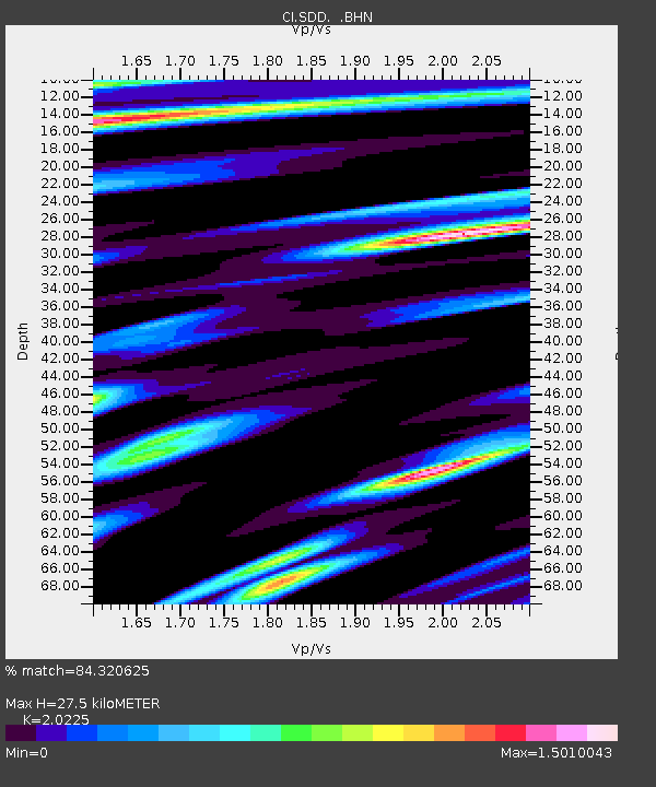
| Estimated Moho Depth: |
27.5 km |
| Estimated Crust Vp/Vs: |
2.02 |
| Assumed Crust Vp: |
6.264 km/s |
| Estimated Crust Vs: |
3.097 km/s |
| Estimated Crust Poisson's Ratio: |
0.34 |
|
| Radial Match: |
84.320625 % |
| Radial Bump: |
400 |
| Transverse Match: |
83.039406 % |
| Transverse Bump: |
400 |
| SOD ConfigId: |
3787 |
| Insert Time: |
2010-02-26 00:55:37.955 +0000 |
| GWidth: |
2.5 |
| Max Bumps: |
400 |
| Tol: |
0.001 |
|

Signal To Noise
| Channel | StoN | STA | LTA |
| CI:SDD: :BHN:20021117T05:03:45.355002Z | 16.903767 | 1.7982149E-5 | 1.0637954E-6 |
| CI:SDD: :BHE:20021117T05:03:45.355002Z | 19.05103 | 1.7283059E-5 | 9.0719817E-7 |
| CI:SDD: :BHZ:20021117T05:03:45.355002Z | 110.4938 | 5.5762634E-5 | 5.046676E-7 |
| Arrivals |
| Ps | 4.6 SECOND |
| PpPs | 13 SECOND |
| PsPs/PpSs | 18 SECOND |


