You are here: Home > Network List > CB - China National Seismic Network Stations List
> Station HEH Heihe,Heilongjiang Province > Earthquake Result Viewer
HEH Heihe,Heilongjiang Province - Earthquake Result Viewer
| Earthquake location: |
Solomon Islands |
| Earthquake latitude/longitude: |
-10.7/161.1 |
| Earthquake time(UTC): |
2016/12/09 (344) 19:10:07 GMT |
| Earthquake Depth: |
21 km |
| Earthquake Magnitude: |
6.9 Mww |
| Earthquake Catalog/Contributor: |
NEIC PDE/us |
|
| Network: |
CB China National Seismic Network |
| Station: |
HEH Heihe,Heilongjiang Province |
| Lat/Lon: |
50.25 N/127.41 E |
| Elevation: |
165 m |
|
| Distance: |
67.5 deg |
| Az: |
337.316 deg |
| Baz: |
143.818 deg |
| Ray Param: |
0.056892306 |
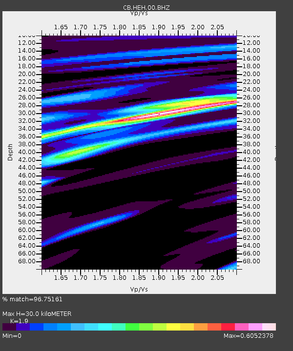
| Estimated Moho Depth: |
30.0 km |
| Estimated Crust Vp/Vs: |
1.90 |
| Assumed Crust Vp: |
6.419 km/s |
| Estimated Crust Vs: |
3.379 km/s |
| Estimated Crust Poisson's Ratio: |
0.31 |
|
| Radial Match: |
96.75161 % |
| Radial Bump: |
246 |
| Transverse Match: |
78.72741 % |
| Transverse Bump: |
400 |
| SOD ConfigId: |
11737051 |
| Insert Time: |
2019-04-26 06:43:24.162 +0000 |
| GWidth: |
2.5 |
| Max Bumps: |
400 |
| Tol: |
0.001 |
|
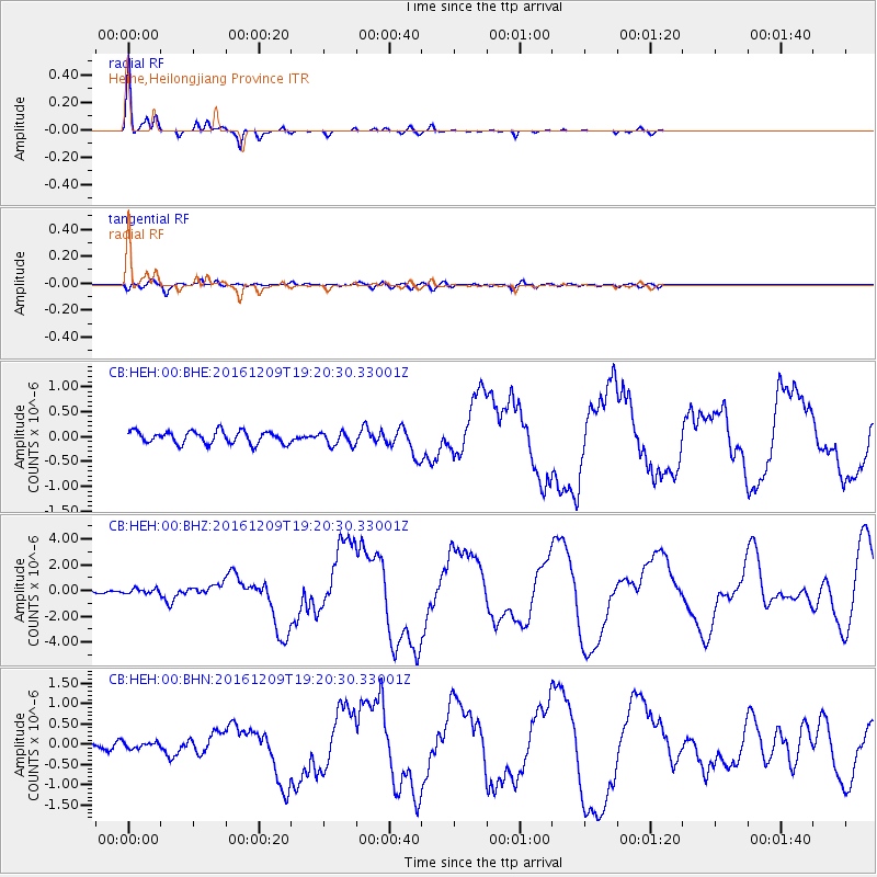
Signal To Noise
| Channel | StoN | STA | LTA |
| CB:HEH:00:BHZ:20161209T19:20:30.33001Z | 2.086393 | 2.2072867E-7 | 1.0579438E-7 |
| CB:HEH:00:BHN:20161209T19:20:30.33001Z | 0.62558633 | 7.45577E-8 | 1.19180505E-7 |
| CB:HEH:00:BHE:20161209T19:20:30.33001Z | 1.1112098 | 1.3608664E-7 | 1.224671E-7 |
| Arrivals |
| Ps | 4.4 SECOND |
| PpPs | 13 SECOND |
| PsPs/PpSs | 17 SECOND |


