You are here: Home > Network List > CI - Caltech Regional Seismic Network Stations List
> Station MPM Manuel Prospect Mine, California, USA > Earthquake Result Viewer
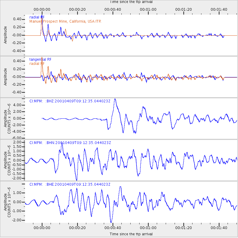
MPM Manuel Prospect Mine, California, USA - Earthquake Result Viewer

| Earthquake location: |
Off Coast Of Central Chile |
| Earthquake latitude/longitude: |
-32.7/-73.1 |
| Earthquake time(UTC): |
2001/04/09 (099) 09:00:57 GMT |
| Earthquake Depth: |
11 km |
| Earthquake Magnitude: |
6.1 MB, 6.3 MS, 6.7 MW, 6.3 ME |
| Earthquake Catalog/Contributor: |
WHDF/NEIC |
|
| Network: |
CI Caltech Regional Seismic Network |
| Station: |
MPM Manuel Prospect Mine, California, USA |
| Lat/Lon: |
36.06 N/117.49 W |
| Elevation: |
185 m |
|
| Distance: |
80.0 deg |
| Az: |
324.867 deg |
| Baz: |
143.2 deg |
| Ray Param: |
0.0485746 |
| Estimated Moho Depth: |
23.5 km |
| Estimated Crust Vp/Vs: |
1.90 |
| Assumed Crust Vp: |
6.279 km/s |
| Estimated Crust Vs: |
3.3 km/s |
| Estimated Crust Poisson's Ratio: |
0.31 |
|
| Radial Match: |
93.51192 % |
| Radial Bump: |
400 |
| Transverse Match: |
85.67835 % |
| Transverse Bump: |
400 |
| SOD ConfigId: |
3770 |
| Insert Time: |
2010-03-05 20:25:15.472 +0000 |
| GWidth: |
2.5 |
| Max Bumps: |
400 |
| Tol: |
0.001 |
|
Signal To Noise
| Channel | StoN | STA | LTA |
| CI:MPM: :BHN:20010409T09:12:35.044023Z | 0.9586668 | 1.735779E-7 | 1.8106175E-7 |
| CI:MPM: :BHE:20010409T09:12:35.044023Z | 0.96666604 | 1.659005E-7 | 1.7162131E-7 |
| CI:MPM: :BHZ:20010409T09:12:35.044023Z | 1.1566337 | 1.9216372E-7 | 1.6614052E-7 |
| Arrivals |
| Ps | 3.5 SECOND |
| PpPs | 11 SECOND |
| PsPs/PpSs | 14 SECOND |


