You are here: Home > Network List > CB - China National Seismic Network Stations List
> Station XLT Xilinhaote,Neimeng Province > Earthquake Result Viewer
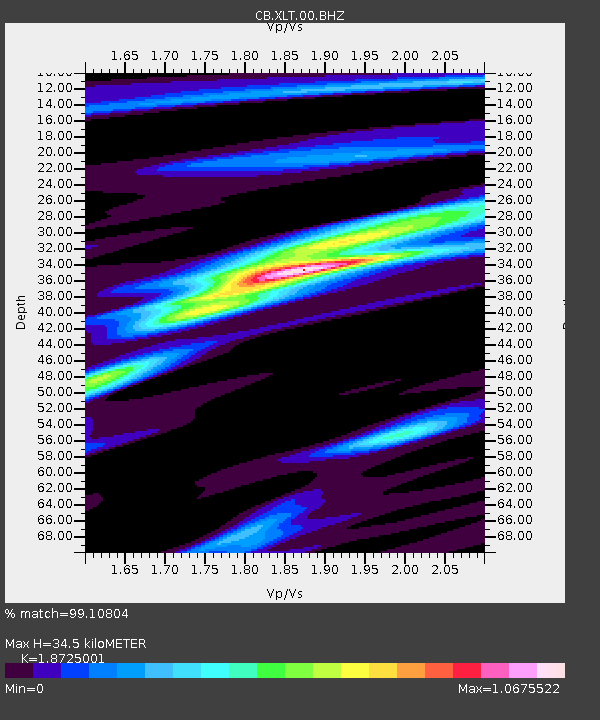
XLT Xilinhaote,Neimeng Province - Earthquake Result Viewer
| Earthquake location: |
Solomon Islands |
| Earthquake latitude/longitude: |
-10.7/161.1 |
| Earthquake time(UTC): |
2016/12/09 (344) 19:10:07 GMT |
| Earthquake Depth: |
21 km |
| Earthquake Magnitude: |
6.9 Mww |
| Earthquake Catalog/Contributor: |
NEIC PDE/us |
|
| Network: |
CB China National Seismic Network |
| Station: |
XLT Xilinhaote,Neimeng Province |
| Lat/Lon: |
43.90 N/116.08 E |
| Elevation: |
1030 m |
|
| Distance: |
68.0 deg |
| Az: |
326.527 deg |
| Baz: |
131.429 deg |
| Ray Param: |
0.056538213 |
| Estimated Moho Depth: |
34.5 km |
| Estimated Crust Vp/Vs: |
1.87 |
| Assumed Crust Vp: |
6.459 km/s |
| Estimated Crust Vs: |
3.45 km/s |
| Estimated Crust Poisson's Ratio: |
0.30 |
|
| Radial Match: |
99.10804 % |
| Radial Bump: |
197 |
| Transverse Match: |
89.22398 % |
| Transverse Bump: |
400 |
| SOD ConfigId: |
11737051 |
| Insert Time: |
2019-04-26 06:43:26.918 +0000 |
| GWidth: |
2.5 |
| Max Bumps: |
400 |
| Tol: |
0.001 |
|

Signal To Noise
| Channel | StoN | STA | LTA |
| CB:XLT:00:BHZ:20161209T19:20:33.749993Z | 2.5528767 | 2.6966526E-7 | 1.05631926E-7 |
| CB:XLT:00:BHN:20161209T19:20:33.749993Z | 1.211096 | 9.822955E-8 | 8.110798E-8 |
| CB:XLT:00:BHE:20161209T19:20:33.749993Z | 1.1801138 | 1.2613384E-7 | 1.0688277E-7 |
| Arrivals |
| Ps | 4.8 SECOND |
| PpPs | 15 SECOND |
| PsPs/PpSs | 20 SECOND |


