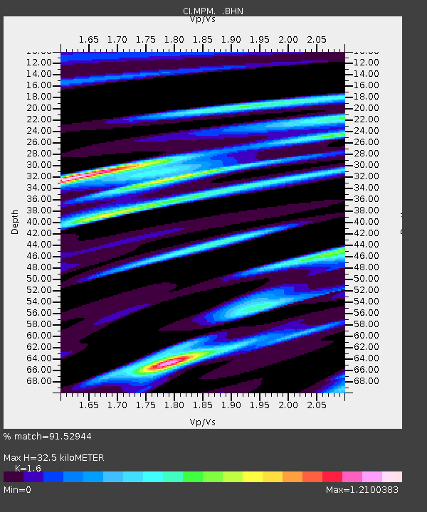
MPM Manuel Prospect Mine, California, USA - Earthquake Result Viewer
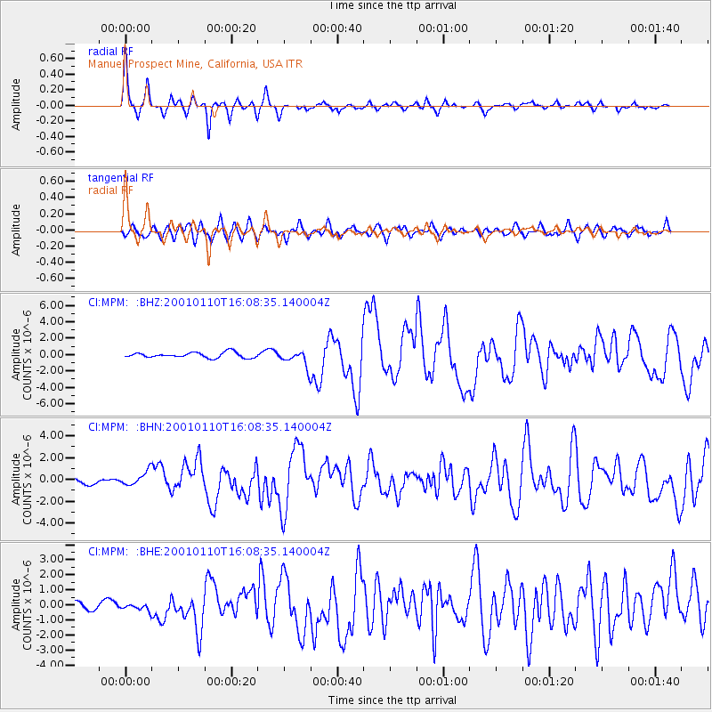
Earthquake location: Kodiak Island Region, Alaska
Earthquake latitude/longitude: 57.1/-153.2
Earthquake time(UTC): 2001/01/10 (010) 16:02:44 GMT
Earthquake Depth: 33 km
Earthquake Magnitude: 6.2 MB, 6.8 MS, 7.1 MW, 6.8 ML
Earthquake Catalog/Contributor: WHDF/NEIC
Network: CI Caltech Regional Seismic Network
Station: MPM Manuel Prospect Mine, California, USA
Lat/Lon: 36.06 N/117.49 W
Elevation: 185 m
Distance: 31.8 deg
Az: 116.035 deg
Baz: 322.733 deg
Ray Param: 0.07888576
Estimated Moho Depth: 32.5 km
Estimated Crust Vp/Vs: 1.60
Assumed Crust Vp: 6.279 km/s
Estimated Crust Vs: 3.924 km/s
Estimated Crust Poisson's Ratio: 0.18
Radial Match: 91.52944 %
Radial Bump: 369
Transverse Match: 77.45228 %
Transverse Bump: 400
SOD ConfigId: 3787
Insert Time: 2010-03-05 20:25:21.880 +0000
GWidth: 2.5
Max Bumps: 400
Tol: 0.001

Signal To Noise

ChannelStoNSTALTA
CI:MPM: :BHN:20010110T16:08:35.140004Z2.70786056.7535524E-72.4940547E-7
CI:MPM: :BHE:20010110T16:08:35.140004Z1.11549642.0312653E-71.8209519E-7
CI:MPM: :BHZ:20010110T16:08:35.140004Z3.1573241.0253281E-63.247459E-7
Arrivals
Ps3.4 SECOND
PpPs12 SECOND
PsPs/PpSs16 SECOND