You are here: Home > Network List > PS - Pacific21 Stations List
> Station PSI Parapat, Indonesia > Earthquake Result Viewer
PSI Parapat, Indonesia - Earthquake Result Viewer
| Earthquake location: |
Solomon Islands |
| Earthquake latitude/longitude: |
-10.7/161.1 |
| Earthquake time(UTC): |
2016/12/09 (344) 19:10:07 GMT |
| Earthquake Depth: |
21 km |
| Earthquake Magnitude: |
6.9 Mww |
| Earthquake Catalog/Contributor: |
NEIC PDE/us |
|
| Network: |
PS Pacific21 |
| Station: |
PSI Parapat, Indonesia |
| Lat/Lon: |
2.69 N/98.92 E |
| Elevation: |
987 m |
|
| Distance: |
63.3 deg |
| Az: |
278.509 deg |
| Baz: |
103.362 deg |
| Ray Param: |
0.059636265 |
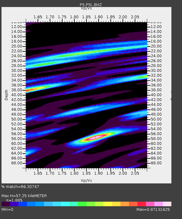
| Estimated Moho Depth: |
57.25 km |
| Estimated Crust Vp/Vs: |
1.88 |
| Assumed Crust Vp: |
6.468 km/s |
| Estimated Crust Vs: |
3.431 km/s |
| Estimated Crust Poisson's Ratio: |
0.30 |
|
| Radial Match: |
96.30747 % |
| Radial Bump: |
400 |
| Transverse Match: |
92.665825 % |
| Transverse Bump: |
400 |
| SOD ConfigId: |
11737051 |
| Insert Time: |
2019-04-26 06:45:15.869 +0000 |
| GWidth: |
2.5 |
| Max Bumps: |
400 |
| Tol: |
0.001 |
|
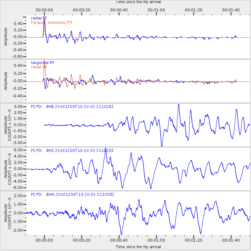
Signal To Noise
| Channel | StoN | STA | LTA |
| PS:PSI: :BHZ:20161209T19:20:03.311028Z | 4.010858 | 4.1931037E-7 | 1.0454381E-7 |
| PS:PSI: :BHN:20161209T19:20:03.311028Z | 0.9800735 | 1.5835697E-7 | 1.6157664E-7 |
| PS:PSI: :BHE:20161209T19:20:03.311028Z | 2.1241326 | 1.731597E-7 | 8.152019E-8 |
| Arrivals |
| Ps | 8.2 SECOND |
| PpPs | 24 SECOND |
| PsPs/PpSs | 33 SECOND |


