You are here: Home > Network List > CI - Caltech Regional Seismic Network Stations List
> Station MPM Manuel Prospect Mine, California, USA > Earthquake Result Viewer
MPM Manuel Prospect Mine, California, USA - Earthquake Result Viewer
| Earthquake location: |
Mariana Islands Region |
| Earthquake latitude/longitude: |
21.6/143.0 |
| Earthquake time(UTC): |
2001/07/03 (184) 13:10:42 GMT |
| Earthquake Depth: |
290 km |
| Earthquake Magnitude: |
6.0 MB, 6.5 MW, 6.5 MW |
| Earthquake Catalog/Contributor: |
WHDF/NEIC |
|
| Network: |
CI Caltech Regional Seismic Network |
| Station: |
MPM Manuel Prospect Mine, California, USA |
| Lat/Lon: |
36.06 N/117.49 W |
| Elevation: |
185 m |
|
| Distance: |
84.8 deg |
| Az: |
53.358 deg |
| Baz: |
292.887 deg |
| Ray Param: |
0.044469588 |
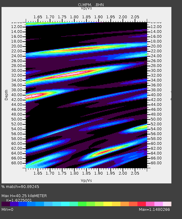
| Estimated Moho Depth: |
40.25 km |
| Estimated Crust Vp/Vs: |
1.62 |
| Assumed Crust Vp: |
6.279 km/s |
| Estimated Crust Vs: |
3.87 km/s |
| Estimated Crust Poisson's Ratio: |
0.19 |
|
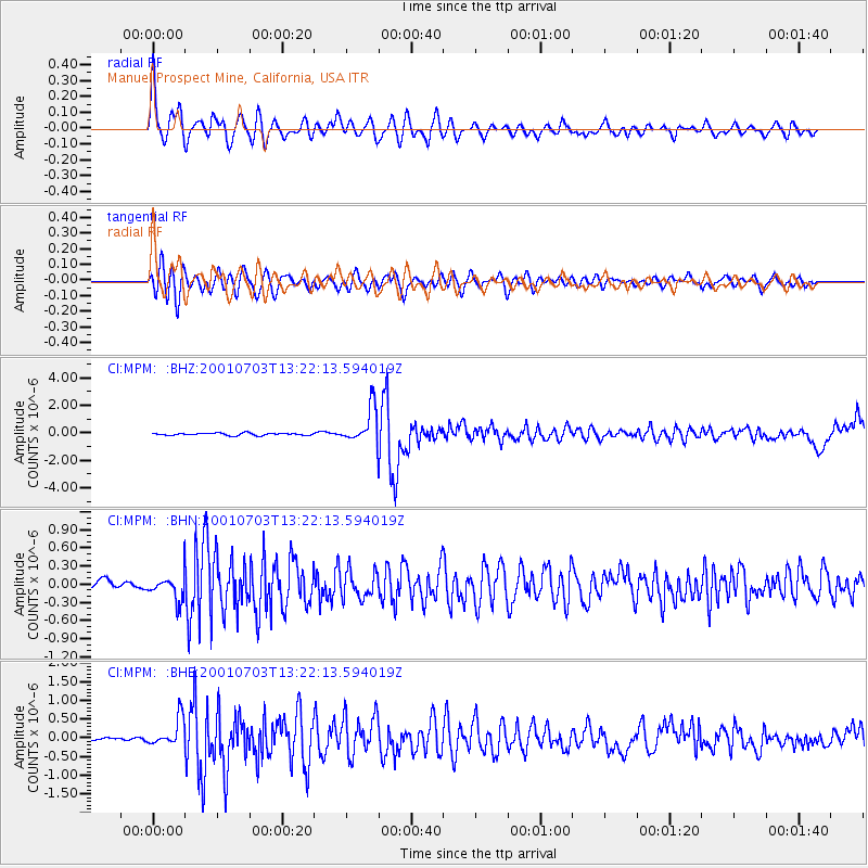
| Radial Match: |
90.89245 % |
| Radial Bump: |
400 |
| Transverse Match: |
81.66252 % |
| Transverse Bump: |
400 |
| SOD ConfigId: |
3787 |
| Insert Time: |
2010-03-05 20:25:37.495 +0000 |
| GWidth: |
2.5 |
| Max Bumps: |
400 |
| Tol: |
0.001 |
|
Signal To Noise
| Channel | StoN | STA | LTA |
| CI:MPM: :BHN:20010703T13:22:13.594019Z | 2.1871684 | 2.0123623E-7 | 9.200766E-8 |
| CI:MPM: :BHE:20010703T13:22:13.594019Z | 7.840215 | 3.7404448E-7 | 4.7708443E-8 |
| CI:MPM: :BHZ:20010703T13:22:13.594019Z | 16.296318 | 1.2968679E-6 | 7.958043E-8 |
| Arrivals |
| Ps | 4.1 SECOND |
| PpPs | 16 SECOND |
| PsPs/PpSs | 20 SECOND |


