You are here: Home > Network List > TA - USArray Transportable Network (new EarthScope stations) Stations List
> Station L19K White Mountain, AK, USA > Earthquake Result Viewer
L19K White Mountain, AK, USA - Earthquake Result Viewer
| Earthquake location: |
Solomon Islands |
| Earthquake latitude/longitude: |
-10.7/161.1 |
| Earthquake time(UTC): |
2016/12/09 (344) 19:10:07 GMT |
| Earthquake Depth: |
21 km |
| Earthquake Magnitude: |
6.9 Mww |
| Earthquake Catalog/Contributor: |
NEIC PDE/us |
|
| Network: |
TA USArray Transportable Network (new EarthScope stations) |
| Station: |
L19K White Mountain, AK, USA |
| Lat/Lon: |
62.18 N/154.85 W |
| Elevation: |
650 m |
|
| Distance: |
80.3 deg |
| Az: |
19.312 deg |
| Baz: |
223.848 deg |
| Ray Param: |
0.048325457 |
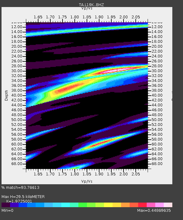
| Estimated Moho Depth: |
29.5 km |
| Estimated Crust Vp/Vs: |
1.97 |
| Assumed Crust Vp: |
6.438 km/s |
| Estimated Crust Vs: |
3.264 km/s |
| Estimated Crust Poisson's Ratio: |
0.33 |
|
| Radial Match: |
93.76613 % |
| Radial Bump: |
396 |
| Transverse Match: |
85.90127 % |
| Transverse Bump: |
400 |
| SOD ConfigId: |
11737051 |
| Insert Time: |
2019-04-26 06:46:07.545 +0000 |
| GWidth: |
2.5 |
| Max Bumps: |
400 |
| Tol: |
0.001 |
|
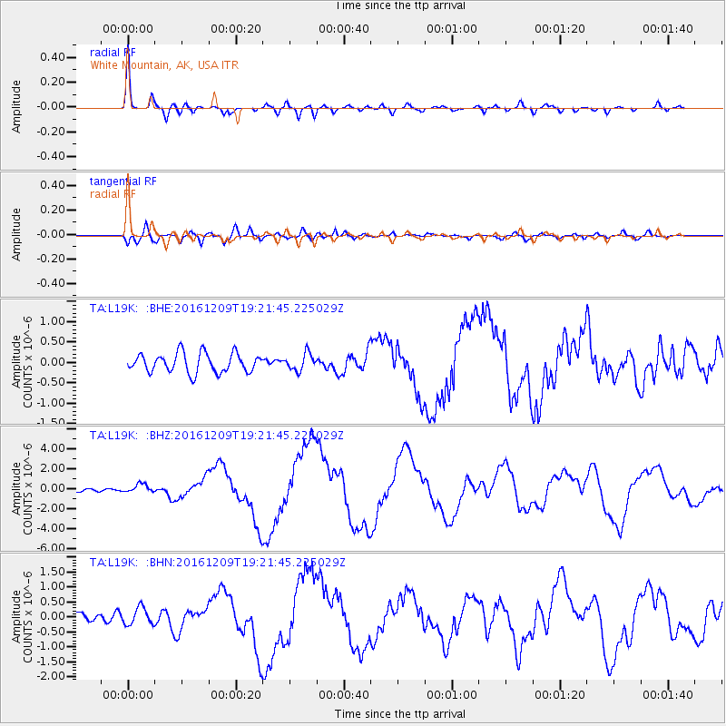
Signal To Noise
| Channel | StoN | STA | LTA |
| TA:L19K: :BHZ:20161209T19:21:45.225029Z | 2.3461175 | 4.1707122E-7 | 1.7777081E-7 |
| TA:L19K: :BHN:20161209T19:21:45.225029Z | 1.7816503 | 2.8587897E-7 | 1.604574E-7 |
| TA:L19K: :BHE:20161209T19:21:45.225029Z | 0.88842267 | 2.0870087E-7 | 2.349117E-7 |
| Arrivals |
| Ps | 4.6 SECOND |
| PpPs | 13 SECOND |
| PsPs/PpSs | 18 SECOND |


