You are here: Home > Network List > TA - USArray Transportable Network (new EarthScope stations) Stations List
> Station P33M Teslin, Yukon, CA > Earthquake Result Viewer
P33M Teslin, Yukon, CA - Earthquake Result Viewer
| Earthquake location: |
Solomon Islands |
| Earthquake latitude/longitude: |
-10.7/161.1 |
| Earthquake time(UTC): |
2016/12/09 (344) 19:10:07 GMT |
| Earthquake Depth: |
21 km |
| Earthquake Magnitude: |
6.9 Mww |
| Earthquake Catalog/Contributor: |
NEIC PDE/us |
|
| Network: |
TA USArray Transportable Network (new EarthScope stations) |
| Station: |
P33M Teslin, Yukon, CA |
| Lat/Lon: |
60.21 N/132.82 W |
| Elevation: |
1066 m |
|
| Distance: |
87.8 deg |
| Az: |
27.174 deg |
| Baz: |
244.003 deg |
| Ray Param: |
0.043049283 |
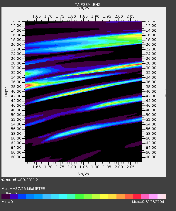
| Estimated Moho Depth: |
37.25 km |
| Estimated Crust Vp/Vs: |
1.60 |
| Assumed Crust Vp: |
6.419 km/s |
| Estimated Crust Vs: |
4.012 km/s |
| Estimated Crust Poisson's Ratio: |
0.18 |
|
| Radial Match: |
89.28112 % |
| Radial Bump: |
400 |
| Transverse Match: |
50.84482 % |
| Transverse Bump: |
400 |
| SOD ConfigId: |
11737051 |
| Insert Time: |
2019-04-26 06:46:16.286 +0000 |
| GWidth: |
2.5 |
| Max Bumps: |
400 |
| Tol: |
0.001 |
|

Signal To Noise
| Channel | StoN | STA | LTA |
| TA:P33M: :BHZ:20161209T19:22:23.025017Z | 1.7857726 | 3.5476597E-7 | 1.9866246E-7 |
| TA:P33M: :BHN:20161209T19:22:23.025017Z | 2.3361988 | 4.840009E-7 | 2.0717454E-7 |
| TA:P33M: :BHE:20161209T19:22:23.025017Z | 0.8059681 | 1.857776E-7 | 2.3050242E-7 |
| Arrivals |
| Ps | 3.6 SECOND |
| PpPs | 15 SECOND |
| PsPs/PpSs | 18 SECOND |


