You are here: Home > Network List > CI - Caltech Regional Seismic Network Stations List
> Station MPM Manuel Prospect Mine, California, USA > Earthquake Result Viewer
MPM Manuel Prospect Mine, California, USA - Earthquake Result Viewer
| Earthquake location: |
Near Coast Of Peru |
| Earthquake latitude/longitude: |
-17.5/-72.1 |
| Earthquake time(UTC): |
2001/07/07 (188) 09:38:43 GMT |
| Earthquake Depth: |
33 km |
| Earthquake Magnitude: |
6.6 MB, 7.3 MS, 7.6 MW, 7.5 ME |
| Earthquake Catalog/Contributor: |
WHDF/NEIC |
|
| Network: |
CI Caltech Regional Seismic Network |
| Station: |
MPM Manuel Prospect Mine, California, USA |
| Lat/Lon: |
36.06 N/117.49 W |
| Elevation: |
185 m |
|
| Distance: |
68.5 deg |
| Az: |
321.655 deg |
| Baz: |
133.074 deg |
| Ray Param: |
0.056238376 |
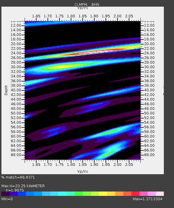
| Estimated Moho Depth: |
23.25 km |
| Estimated Crust Vp/Vs: |
1.91 |
| Assumed Crust Vp: |
6.279 km/s |
| Estimated Crust Vs: |
3.292 km/s |
| Estimated Crust Poisson's Ratio: |
0.31 |
|
| Radial Match: |
96.9371 % |
| Radial Bump: |
400 |
| Transverse Match: |
89.63532 % |
| Transverse Bump: |
400 |
| SOD ConfigId: |
3770 |
| Insert Time: |
2010-03-05 20:25:47.464 +0000 |
| GWidth: |
2.5 |
| Max Bumps: |
400 |
| Tol: |
0.001 |
|
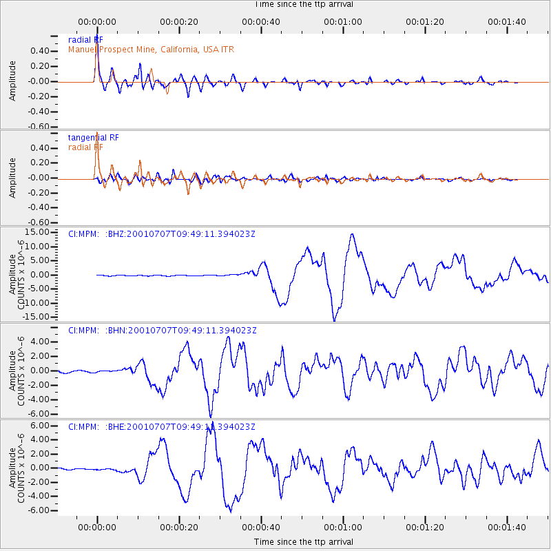
Signal To Noise
| Channel | StoN | STA | LTA |
| CI:MPM: :BHN:20010707T09:49:11.394023Z | 0.8846773 | 1.2722741E-7 | 1.4381222E-7 |
| CI:MPM: :BHE:20010707T09:49:11.394023Z | 1.1538483 | 8.959673E-8 | 7.7650355E-8 |
| CI:MPM: :BHZ:20010707T09:49:11.394023Z | 1.7579787 | 2.2494545E-7 | 1.2795687E-7 |
| Arrivals |
| Ps | 3.5 SECOND |
| PpPs | 10 SECOND |
| PsPs/PpSs | 14 SECOND |


