You are here: Home > Network List > CI - Caltech Regional Seismic Network Stations List
> Station MPM Manuel Prospect Mine, California, USA > Earthquake Result Viewer
MPM Manuel Prospect Mine, California, USA - Earthquake Result Viewer
| Earthquake location: |
Near Coast Of Peru |
| Earthquake latitude/longitude: |
-16.3/-73.6 |
| Earthquake time(UTC): |
2001/06/23 (174) 20:33:14 GMT |
| Earthquake Depth: |
33 km |
| Earthquake Magnitude: |
6.7 MB, 8.2 MS, 8.4 MW, 7.8 ME |
| Earthquake Catalog/Contributor: |
WHDF/NEIC |
|
| Network: |
CI Caltech Regional Seismic Network |
| Station: |
MPM Manuel Prospect Mine, California, USA |
| Lat/Lon: |
36.06 N/117.49 W |
| Elevation: |
185 m |
|
| Distance: |
66.5 deg |
| Az: |
322.271 deg |
| Baz: |
133.503 deg |
| Ray Param: |
0.057498094 |
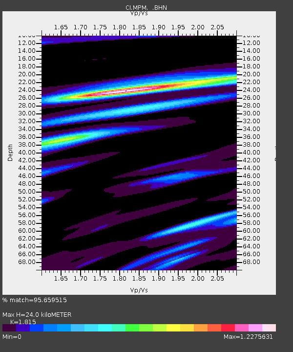
| Estimated Moho Depth: |
24.0 km |
| Estimated Crust Vp/Vs: |
1.82 |
| Assumed Crust Vp: |
6.279 km/s |
| Estimated Crust Vs: |
3.459 km/s |
| Estimated Crust Poisson's Ratio: |
0.28 |
|
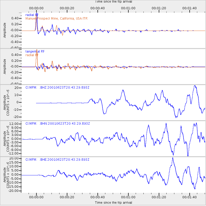
| Radial Match: |
95.659515 % |
| Radial Bump: |
389 |
| Transverse Match: |
85.83129 % |
| Transverse Bump: |
400 |
| SOD ConfigId: |
3787 |
| Insert Time: |
2010-03-05 20:25:50.347 +0000 |
| GWidth: |
2.5 |
| Max Bumps: |
400 |
| Tol: |
0.001 |
|
Signal To Noise
| Channel | StoN | STA | LTA |
| CI:MPM: :BHN:20010623T20:43:29.893Z | 4.0794396 | 3.2166912E-7 | 7.88513E-8 |
| CI:MPM: :BHE:20010623T20:43:29.893Z | 6.0091453 | 3.9849013E-7 | 6.6313945E-8 |
| CI:MPM: :BHZ:20010623T20:43:29.893Z | 9.262776 | 1.084593E-6 | 1.17091574E-7 |
| Arrivals |
| Ps | 3.2 SECOND |
| PpPs | 10 SECOND |
| PsPs/PpSs | 14 SECOND |


