You are here: Home > Network List > CI - Caltech Regional Seismic Network Stations List
> Station SDD Saddleback, Mission Viejo, CA, USA > Earthquake Result Viewer
SDD Saddleback, Mission Viejo, CA, USA - Earthquake Result Viewer

| Earthquake location: |
North Atlantic Ocean |
| Earthquake latitude/longitude: |
18.3/-58.6 |
| Earthquake time(UTC): |
2003/05/14 (134) 06:03:35 GMT |
| Earthquake Depth: |
42 km |
| Earthquake Magnitude: |
6.5 MB, 6.5 MS, 6.6 MW, 6.6 MW |
| Earthquake Catalog/Contributor: |
WHDF/NEIC |
|
| Network: |
CI Caltech Regional Seismic Network |
| Station: |
SDD Saddleback, Mission Viejo, CA, USA |
| Lat/Lon: |
33.55 N/117.66 W |
| Elevation: |
120 m |
|
| Distance: |
54.6 deg |
| Az: |
298.506 deg |
| Baz: |
90.623 deg |
| Ray Param: |
0.06528105 |
| Estimated Moho Depth: |
15.25 km |
| Estimated Crust Vp/Vs: |
1.60 |
| Assumed Crust Vp: |
6.264 km/s |
| Estimated Crust Vs: |
3.915 km/s |
| Estimated Crust Poisson's Ratio: |
0.18 |
|
| Radial Match: |
82.74776 % |
| Radial Bump: |
400 |
| Transverse Match: |
76.601494 % |
| Transverse Bump: |
400 |
| SOD ConfigId: |
3770 |
| Insert Time: |
2010-02-26 00:55:44.030 +0000 |
| GWidth: |
2.5 |
| Max Bumps: |
400 |
| Tol: |
0.001 |
|
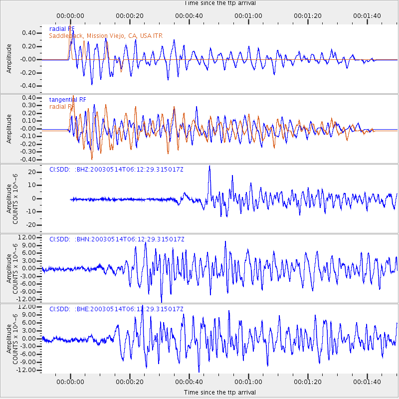
Signal To Noise
| Channel | StoN | STA | LTA |
| CI:SDD: :BHN:20030514T06:12:29.315017Z | 1.0653564 | 4.997898E-7 | 4.6912922E-7 |
| CI:SDD: :BHE:20030514T06:12:29.315017Z | 0.83072776 | 4.6142492E-7 | 5.554466E-7 |
| CI:SDD: :BHZ:20030514T06:12:29.315017Z | 1.0651954 | 4.5151936E-7 | 4.2388407E-7 |
| Arrivals |
| Ps | 1.5 SECOND |
| PpPs | 6.0 SECOND |
| PsPs/PpSs | 7.5 SECOND |


