You are here: Home > Network List > TA - USArray Transportable Network (new EarthScope stations) Stations List
> Station G23K Bananza Creek, AK, USA > Earthquake Result Viewer
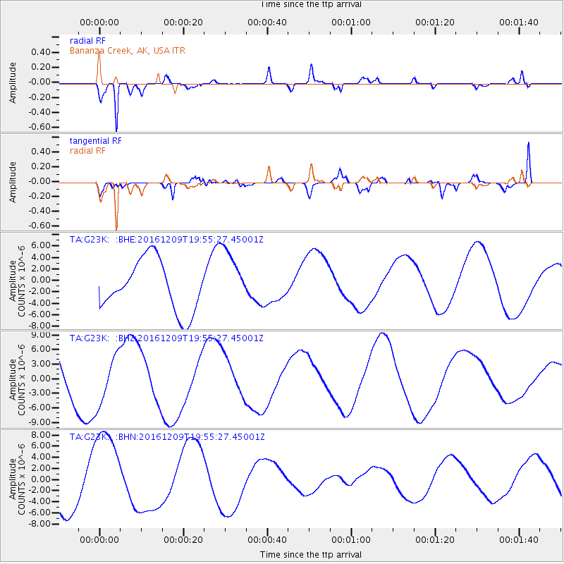
G23K Bananza Creek, AK, USA - Earthquake Result Viewer
*The percent match for this event was below the threshold and hence no stack was calculated.
| Earthquake location: |
Solomon Islands |
| Earthquake latitude/longitude: |
-11.0/161.3 |
| Earthquake time(UTC): |
2016/12/09 (344) 19:43:23 GMT |
| Earthquake Depth: |
18 km |
| Earthquake Magnitude: |
5.5 mb |
| Earthquake Catalog/Contributor: |
NEIC PDE/us |
|
| Network: |
TA USArray Transportable Network (new EarthScope stations) |
| Station: |
G23K Bananza Creek, AK, USA |
| Lat/Lon: |
66.71 N/150.02 W |
| Elevation: |
746 m |
|
| Distance: |
85.1 deg |
| Az: |
17.43 deg |
| Baz: |
227.711 deg |
| Ray Param: |
$rayparam |
*The percent match for this event was below the threshold and hence was not used in the summary stack. |
|
| Radial Match: |
91.28111 % |
| Radial Bump: |
400 |
| Transverse Match: |
67.3196 % |
| Transverse Bump: |
400 |
| SOD ConfigId: |
11737051 |
| Insert Time: |
2019-04-26 06:51:29.342 +0000 |
| GWidth: |
2.5 |
| Max Bumps: |
400 |
| Tol: |
0.001 |
|
Signal To Noise
| Channel | StoN | STA | LTA |
| TA:G23K: :BHZ:20161209T19:55:27.45001Z | 0.8481561 | 4.879219E-6 | 5.7527373E-6 |
| TA:G23K: :BHN:20161209T19:55:27.45001Z | 2.3712213 | 8.38402E-6 | 3.5357389E-6 |
| TA:G23K: :BHE:20161209T19:55:27.45001Z | 1.1464094 | 4.9936693E-6 | 4.355921E-6 |
| Arrivals |
| Ps | |
| PpPs | |
| PsPs/PpSs | |


