You are here: Home > Network List > TA - USArray Transportable Network (new EarthScope stations) Stations List
> Station M20K Styx River, AK, USA > Earthquake Result Viewer
M20K Styx River, AK, USA - Earthquake Result Viewer
| Earthquake location: |
Solomon Islands |
| Earthquake latitude/longitude: |
-11.0/161.3 |
| Earthquake time(UTC): |
2016/12/09 (344) 19:43:23 GMT |
| Earthquake Depth: |
18 km |
| Earthquake Magnitude: |
5.5 mb |
| Earthquake Catalog/Contributor: |
NEIC PDE/us |
|
| Network: |
TA USArray Transportable Network (new EarthScope stations) |
| Station: |
M20K Styx River, AK, USA |
| Lat/Lon: |
61.88 N/153.13 W |
| Elevation: |
1107 m |
|
| Distance: |
80.8 deg |
| Az: |
20.029 deg |
| Baz: |
225.229 deg |
| Ray Param: |
0.047998372 |
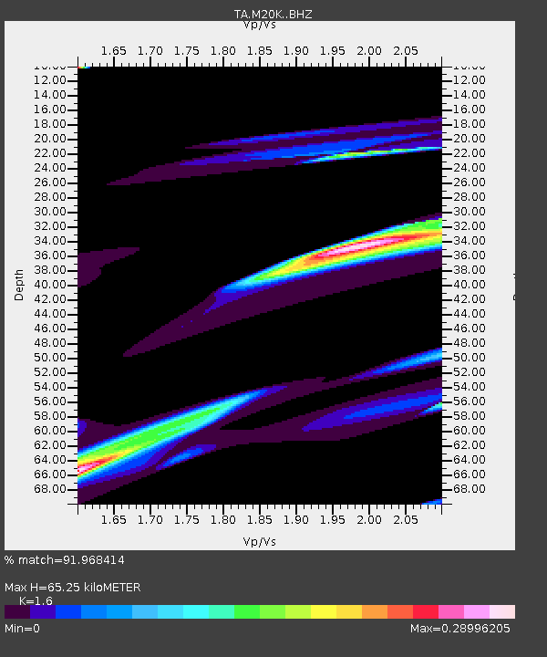
| Estimated Moho Depth: |
65.25 km |
| Estimated Crust Vp/Vs: |
1.60 |
| Assumed Crust Vp: |
6.566 km/s |
| Estimated Crust Vs: |
4.104 km/s |
| Estimated Crust Poisson's Ratio: |
0.18 |
|
| Radial Match: |
91.968414 % |
| Radial Bump: |
400 |
| Transverse Match: |
67.0771 % |
| Transverse Bump: |
396 |
| SOD ConfigId: |
11737051 |
| Insert Time: |
2019-04-26 06:51:35.384 +0000 |
| GWidth: |
2.5 |
| Max Bumps: |
400 |
| Tol: |
0.001 |
|

Signal To Noise
| Channel | StoN | STA | LTA |
| TA:M20K: :BHZ:20161209T19:55:05.150022Z | 1.1419139 | 3.4331454E-6 | 3.0064837E-6 |
| TA:M20K: :BHN:20161209T19:55:05.150022Z | 1.7212374 | 5.997093E-6 | 3.4841753E-6 |
| TA:M20K: :BHE:20161209T19:55:05.150022Z | 0.7796371 | 2.572875E-6 | 3.300093E-6 |
| Arrivals |
| Ps | 6.2 SECOND |
| PpPs | 25 SECOND |
| PsPs/PpSs | 31 SECOND |


