You are here: Home > Network List > TA - USArray Transportable Network (new EarthScope stations) Stations List
> Station M30M Minto, Yukon, CA > Earthquake Result Viewer
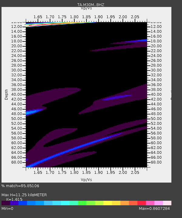
M30M Minto, Yukon, CA - Earthquake Result Viewer
| Earthquake location: |
Solomon Islands |
| Earthquake latitude/longitude: |
-11.0/161.3 |
| Earthquake time(UTC): |
2016/12/09 (344) 19:43:23 GMT |
| Earthquake Depth: |
18 km |
| Earthquake Magnitude: |
5.5 mb |
| Earthquake Catalog/Contributor: |
NEIC PDE/us |
|
| Network: |
TA USArray Transportable Network (new EarthScope stations) |
| Station: |
M30M Minto, Yukon, CA |
| Lat/Lon: |
62.58 N/136.79 W |
| Elevation: |
782 m |
|
| Distance: |
87.3 deg |
| Az: |
24.129 deg |
| Baz: |
240.11 deg |
| Ray Param: |
0.043394685 |
| Estimated Moho Depth: |
11.25 km |
| Estimated Crust Vp/Vs: |
1.62 |
| Assumed Crust Vp: |
6.566 km/s |
| Estimated Crust Vs: |
4.066 km/s |
| Estimated Crust Poisson's Ratio: |
0.19 |
|
| Radial Match: |
95.85106 % |
| Radial Bump: |
400 |
| Transverse Match: |
48.310497 % |
| Transverse Bump: |
329 |
| SOD ConfigId: |
11737051 |
| Insert Time: |
2019-04-26 06:51:35.789 +0000 |
| GWidth: |
2.5 |
| Max Bumps: |
400 |
| Tol: |
0.001 |
|

Signal To Noise
| Channel | StoN | STA | LTA |
| TA:M30M: :BHZ:20161209T19:55:38.07501Z | 1.6259849 | 1.04862E-5 | 6.4491373E-6 |
| TA:M30M: :BHN:20161209T19:55:38.07501Z | 1.6940671 | 4.423206E-6 | 2.6109983E-6 |
| TA:M30M: :BHE:20161209T19:55:38.07501Z | 1.5351063 | 5.8407086E-6 | 3.8047585E-6 |
| Arrivals |
| Ps | 1.1 SECOND |
| PpPs | 4.4 SECOND |
| PsPs/PpSs | 5.4 SECOND |


